
PAGASA Releases Latest Weather Update for Wednesday (July 8, 2026)
PAGASA LATEST UPDATE – Signal No. 1 has been raised in several parts of the country due to Super Typhoon Inday.
On Wednesday (July 8, 2026), the Philippine Atmospheric, Geophysical and Astronomical Services Administration (PAGASA) released its latest weather update. Super Typhoon Inday has entered the Philippine Area of Responsibility (PAR).
PAGASA weather specialist Chenel Dominguez reported that Inday was last spotted 1,405 kilometers east of Northern Luzon. It has maximum sustained winds of 185 kilometers per hour and gusts of up to 230 kph. It is moving westward at 25 kph.
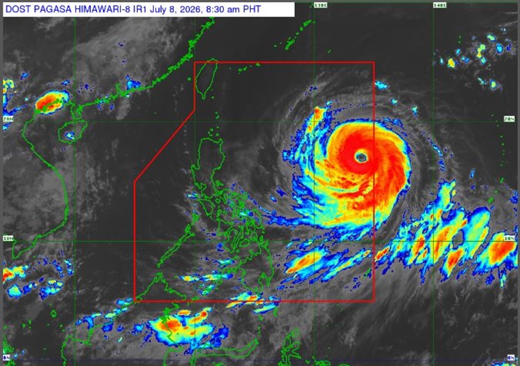
The agency raised Wind Signal No. 1 in the following areas due to the minimal to minor threats posed by the super typhoon:
- Batanes
- Cagayan
- Babuyan Islands
- Northern and central portions of Isabela
- Apayao
- Eastern portion of Kalinga
- Northern portion of Aurora
- Northern and central portions of Catanduanes
Super Typhoon Inday and the enhanced southwest monsoon are expected to bring strong winds to parts of the country.

According to Dominguez, PAGASA does not expect Typhoon Inday to have any direct impact on any part of the country for now. However, the southwest monsoon, or habagat, is expected to bring rainfall to several areas.
The enhanced habagat is forecast to bring cloudy skies and scattered rains over Zamboanga Peninsula, BARMM, Antique, Iloilo, Guimaras, Negros Occidental, Negros Oriental, Lanao del Norte, Sultan Kudarat, Sarangani, and South Cotabato.
It will also bring isolated rain showers or thunderstorms over the Visayas and Mindanao.

Localized thunderstorms may also affect weather conditions over Metro Manila and the rest of Luzon.
The super typhoon is expected to weaken into a typhoon by Thursday afternoon or evening and is forecast to leave the country’s vicinity by Saturday, July 11, 2026.
Meanwhile, sea conditions along the northern and eastern seaboards of Luzon and the Visayas are expected to be rough, according to PAGASA.
This is a developing report, just visit this website regularly or refresh the page for further updates.
READ ALSO: Super Typhoon Bavi Continues Toward PAR, To Bring Heavy Rain Over Parts PH