PAGASA Says Typhoon Goring to Bring Rains Over Parts of PH
PAGASA LATEST UPDATE – The state weather bureau reported that Goring intensified into a super typhoon, signal no. 4 declared in two areas.
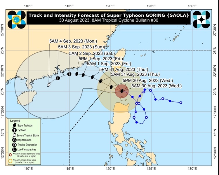
On Wednesday (August 30, 2023), the Philippine Atmospheric, Geophysical and Astronomical Services Administration released the latest weather update in the country. Goring will continue to affect the country’s weather condition.
PAGASA reported that Super typhoon Goring was last spotted over the coastal waters of Sabtang, Batanes. It packs maximum sustained winds of 195 kilometers per hour and gustiness of up to 240 kph.

Goring will bring stormy weather over Batanes and Northeastern Cagayan including Babuyan Islands. Rins with gusty winds are expected over Ilocos Norte, Apayao, and the rest of mainland Cagayan.
The enhanced habagat will bring monsoon rains over Zambales, Bataan, Occidental Mindoro, and the northern portion of Palawan. Occasional rains are expected over Metro Manila, the rest of Ilocos Region, the rest of MIMAROPA, Tarlac, Pampanga, Bulacan, Cavite, and Batangas.
The southwest monsoon will also bring cloudy skies with scattered rain showers and thunderstorms over rest of Luzon, the rest of Western Visayas, and Zamboanga Peninsula.
The weather agency has warned the public for possible flooding or landslides due to moderate to heavy rains and severe thunderstorms.
RELATED ARTICLE: PAGASA: Typhoon Goring Maintains Strength, Storm Outside PAR Accelerates
PAGASA raised various Tropical Cyclone Wind Signals in the following areas.
Signal No. 1
- Rest of Cagayan, Apayao, the northern portion of Kalinga
- Northern portion of Abra
- Rest of Ilocos Norte, and the extreme northern portion of Ilocos Sur
Signal No. 2
- Northern portion of mainland Cagayan
- the northern portion of Ilocos Norte
Signal No. 3
- Rest of Batanes and the southwestern portion of Babuyan Islands
Signal No. 4
- Southern portion of Batanes
- Northern portions of Babuyan Islands
Goring is expected to leave the Philippine area of responsibility on Wednesday evening or on Thursday morning (August 31).
“Gayunpaman, naging napalakas pa rin ng bugso ng hangin na naging dala nito partikular na sa Babuyan Islands at sa bahagi ng Batanes, kung saan malapit ang tinatawag na eye wall or kung saan ang may pinakamalakas na hangin ng bagyo,” Pagasa weather specialist Obet Badrina said.
Meanwhile, severe tropical storm Haikui was spotted 1,560 km east of northern Luzon outside the PAR. It has maximum wind of 11 kph and gustiness of up to 135 kph. The weather disturbance may enter PAR on Wednesday and leave the country’s vicinity by Friday (September 1, 2023).
Thank you for visiting Philippine Trending News (Philnews.ph). You may also follow us on the following social media platforms; Facebook, Twitter, and YouTube