PAGASA Says Severe Tropical Storm Gorio to Bring Rains Over Parts of PH
PAGASA LATEST UPDATE – The state weather bureau reported that Severe Tropical Storm Gorio has entered the country’s vicinity.
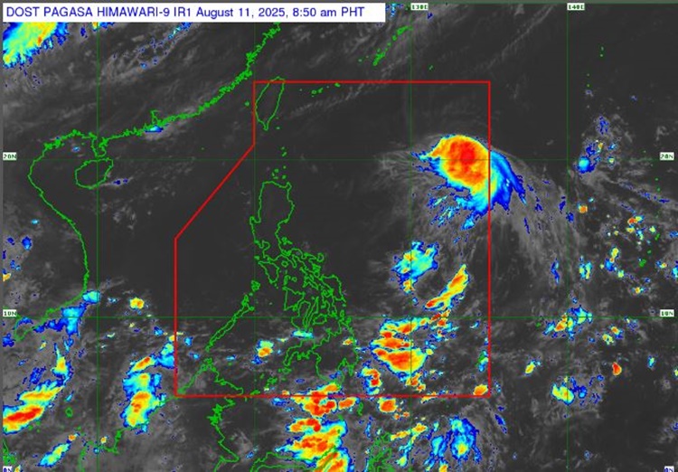
On Monday (August 11, 2025), the Philippine Atmospheric, Geophysical, and Astronomical Services Administration released the latest weather update in the country. Severe Tropical Storm Gorio and habagat will affect the country’s weather conditions.
PAGASA weather specialist Daniel James Villamil reported that Severe Tropical Storm Gorio may intensify into a typhoon within the next 12 hours. The Southwest Monsoon will bring rain showers in other areas.
Gorio has entered the Philippine Area of Responsibility on Sunday evening (August 10, 2025). It was last spotted at 1,305 km east of Extreme Northern Luzon.
The Severe Tropical Storm packs maximum sustained winds of 110 kilometers per hour near the center and gustiness of up to 135 kph, moving 25 kph in a westward direction.
“Wala tayong inaasahang direktang epekto sa ating panahon ngayong araw, Gorio is unlikely to directly affect the country within the next three days,” Villamil said.

The weather agency has advised the residents in the affected areas to take precautionary measures for possible flash floods or landslides due to moderate to at times heavy rains and severe thunderstorms.
Meanwhile, the coastal water condition over Extreme Northern Luzon will be moderate. The remaining parts of the country will have slight to moderate surrounding sea conditions, according to PAGASA.
“Mariners of motor bancas and similarly sized vessels are advised to take precautionary measures while venturing out to sea and, if possible, avoid navigating in these conditions, especially if inexperienced or operating ill-equipped vessels,” Villamil added.
Gorio is expected to leave PAR by Wednesday evening (August 13) or Thursday early morning (August 14).
RELATED POST: PAGASA Releases Latest Weather Update for Saturday (August 9, 2025)