PAGASA Releases Latest Weather Update for Saturday (May 27, 2023)
The state weather bureau PAGASA reported that Super Typhoon Mawar has entered the Philippine Area of Responsibility.
On Saturday (May 27, 2023), the Philippine Atmospheric, Geophysical and Astronomical Services Administration released the latest weather update in the country. Super Typhoon Mawar and the southwesterly windflow will affect the country’s weather condition.
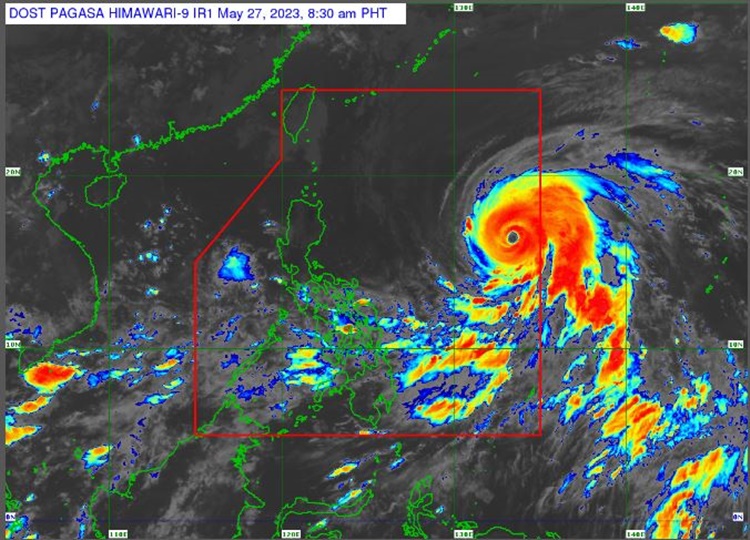
PAGASA reported that Super Typhoon Mawar entered PAR and was named Betty. Mawar’s center of the eye was last spotted at 1,320 kilometers east of Central Luzon. It has maximum sustained winds of 195 kilometers per hour and gustiness of up to 240 kph.

Betty is expected to track generally west northwestward over the weekend. it may become almost stationary next week when it reach near Batanes.
The southwesterly windflow will be affecting the western sections of Southern Luzon, Visayas, and Mindanao.
Betty’s trough and the southwesterly windflow will bring cloudy weather condition with scattered rain showers and thunderstorms over Palawan, Visayas, Zamboanga Peninsula, Northern Mindanao, and Caraga.

The southwesterly windflow and localized thunderstorms will bring cloudy to cloudy skies with isolated rain showers or thunderstorms over Metro Manila and the rest of the country.
The weather agency has warned the public for flash floods or landslides in the affected areas due to moderate to at times heavy rains and severe thunderstorms.
Meanwhile, the coastal water condition over eastern sections of Luzon and Visayas will be moderate to rough. Mindanao and Palawan as well as rest of Luzon and Visayas will have slight to moderate surrounding sea conditions, according to the weather bureau.

What can you say about the latest weather update? Just feel free to leave your comments and reactions to this article.
Thank you for visiting Philippine Trending News (Philnews.ph). You may also follow us on the following social media platforms; Facebook, Twitter, and YouTube
