Tropical Depression Paeng Possible Track Released By PAGASA
The state weather bureau PAGASA has released the possible track of a tropical depression, which will be named “Paeng” if it enters PAR.
On Friday (September 21, 2018), the Philippine Atmospheric, Geophysical, and Astronomical Services Administration (PAGASA) issued the latest update about the tropical depression expected to enter the country’s vicinity on weekend.
PAGASA reported that the low-pressure area spotted at 2,160 kilometers east of Southern Luzon has already intensified into a tropical depression.
The weather disturbance has maximum sustained winds of 55 kilometers per hour (kph) and gustiness of up to 65 kph, moving 20 kph north-northwest.
The tropical depression will be named “Paeng” if it enters the Philippine Area of Responsibility (PAR) on Sunday afternoon (September 23, 2018).
Paeng could possibly intensify into a severe tropical storm on Monday (September 24) and even a typhoon by Tuesday (September 25).
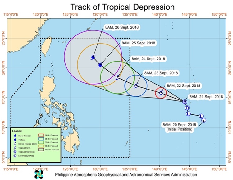
The weather agency said that Paeng is not expected to make a landfall in the country but might enhance the southwest monsoon (Habagat).
The enhanced Habagat may affect the weather condition over extreme Northern Luzon or Batanes.
What can you say about this? Just feel free to leave your comments and reactions to this article.