Bagyong Ruby (Hagupit) got stronger based upon the latest update released by the Philippine weather bureau, PAGASA at around 4:00 PM on Thursday, December 4, 2014. The weather disturbance, Bagyong Ruby is now packing 205 kph winds and gustiness of 240 kph but getting slower at 15 kph. As of 4:00 PM today, the eye of typhoon “Ruby” was located based on all available data at 720 km east of Surigao City.
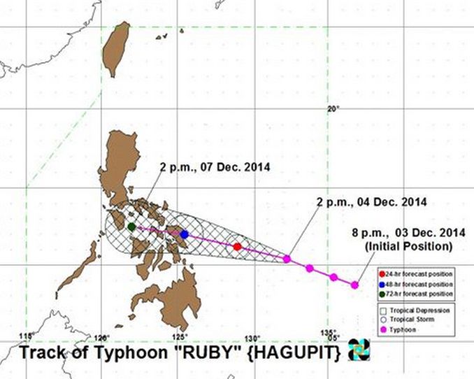
According to PAGASA OIC Vicente Malano, the typhoon has gotten slower and will make landfall on Saturday, December 6, 2014, which will hit the Eastern portion of Samar province.
The Bagyong Hagupit has already been classified by the US Navy’s Joint Typhoon Warning Center (JTWC) as a super typhoon, bearing a maximum sustained winds of 2015 kilometers per hour (kph) and gusts of up to 240 kph.
PAGASA also released the list of Storm Signals which will be affected by Bagyong Ruby (Hagupit), the weather agency also noted that there is a possibility of giving the storm warning signal Number 4, which could be raised in Guiuan, Eastern Samar at the height of the typhoon.
Meanwhile, the Philippine head of state, President Benigno Aquino III, asked PAGASA whether goods and assets can be prepositioned in Guiuan before the expected landfall of the typhoon, the PAGASA official noted that Bagyong Hagupit will affect the entire province of Samar and not only Guiuan.
The national government have also prepared for the rescue and relief operations during and after the typhoon will make a landfall in the country. DILG Secretary Mar Roxas noted that all communities that need to be evacuated have already been alerted.
The PNP has already been placed in heightened alert, and all leaves have been cancelled while the DSWD said that it has started prepositioning food packs for families who will be affected by Bagyong Ruby, they also identified the evacuation centers for individuals who will be displaced.