PAGASA released their latest weather bulletin for Super Typhoon Yolanda at around 5:00 AM to 5:00 PM today, November 7, 2013.
Related Article: Yolanda November 8 Hourly Updates
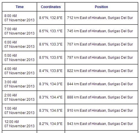
According to PAGASA at around 4:00 AM today, the eye of the Typhoon “Yolanda” was located based on all available data at 822 km east of Hinatuan, Surigao del Sur (8.4ºN, 133.8ºE) with maximum sustained winds of 215 kph near the center and gustiness of up to 250 kph. The Typhoon is forecast to move West Northwest at 30 kph.
Related Article: Super Typhoon Yolanda Storm Signals Nov. 8, 2013
Super Typhoon Yolanda as of 4:00 AM Nov. 7, 2013
Related Article: Super Typhoon Yolanda Could Affect 14.2 million Pinoys
Forecasts: Bicol Region, Visayas and Mindanao will experience cloudy skies with light to moderate rainshowers and thunderstorms. The Region of Cagayan Valley, Cordillera and Ilocos will be partly cloudy to cloudy with light rains. Metro Manila and the rest of Luzon will have partly cloudy to cloudy skies with isolated rainshowers or thunderstorms.
Moderate to strong winds blowing from the Northeast will prevail all over Luzon and Visayas and coming from the Northeast to North over Mindanao. The coastal waters throughout the archiplelago will be moderate to rough.
Related Article: PAGASA Weather Bulletin as of 5:00 PM Nov. 7, 2013
Here’s the Hourly Updates of Super Typhoon Yolanda:
Note: The Hourly Updates of Super Typhoon Yolanda will be added here are soon as available from PAGASA. Just bookmarked this page or Like Us on Facebook or Follow Us on Twitter for updated information of the latest weather disturbance Super Typhoon Yolanda.


