PAGASA Releases Latest Weather Update for Wednesday (April 14)
The state weather bureau PAGASA reported that the tropical storm off Mindanao may intensify into a typhoon and enter PAR on Friday.
On Wednesday (April 14, 2021), the Philippine Atmospheric, Geophysical, and Astronomical Services Administration released the latest weather updates in the country and continue to monitor the tropical storm east of Mindanao.
The tropical storm has maximum sustained winds of 65 kilometers per hour and gustiness of up to 65 kph. It was last spotted at 1,210 kilometers east of Mindanao and moving 10 kph at a west-northwest direction.
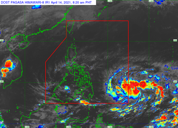
PAGASA said that the tropical storm would be given a local name of “Bising” once it enters the Philippine Area of Responsibility on Friday (April 16). It will be the second storm to enter PAR this year.
The easterlies would bring partly cloudy to cloudy skies with isolated rainshowers or thunderstorms Batanes, Cagayan, Isabela, Quirino, Nueva Vizcaya, Aurora, Apayao, Kalinga, Mountain Province, Ifugao, Abra, Benguet, Ilocos Norte, Ilocos Sur, La Union and Pangasinan.
The localized thunderstorms would also bring the same weather condition over the entire Visayas, Palawan including Kalayaan Islands, and Occidental Mindoro. Metro Manila and the remaining parts of the country would have the same weather condition.

Meanwhile, the coastal water conditions over the eastern sections of Luzon, rest of Luzon, Visayas and Mindanao would be slight to moderate, according to the weather bureau.
What can you say about the recent weather update? Just feel free to leave your comments and reactions to this article.
Read Also: PAGASA Says Easterlies to Bring Rains Over Parts of PH (April 13)