PAGASA Releases Latest Weather Update for Saturday (September 26)
LATEST WEATHER UPDATE – The state weather bureau PAGASA reported that a low-pressure area would affect the country’s weather condition.
On Saturday (September 26, 2020), the Philippine Atmospheric, Geophysical and Astronomical Services Administration released the latest weather updates in the country. The low-pressure would bring rains over some parts of the country.
The low-pressure area is expected to bring cloudy weather conditions with scattered rainshowers and thunderstorms over the provinces of Ilocos Norte, Ilocos Sur, La Union, Pangasinan, Benguet, Abra, Apayao, Kalinga, Ifugao, Mt. Province, Batanes, Cagayan, Isabela, Nueva Vizcaya, Quirino, and Aurora.
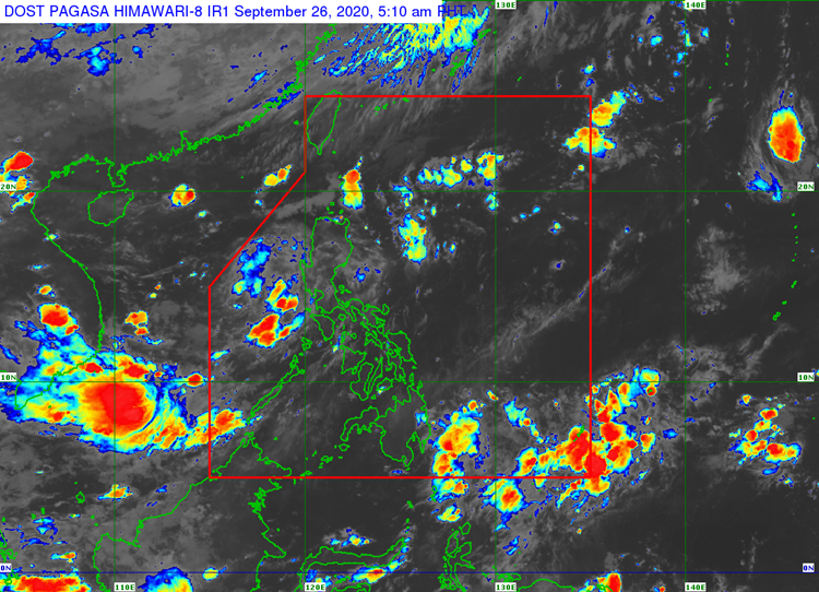
The LPA was last spotted at 405 km East of Tuguegarao City, Cagayan (18.1 N, 125.5 E). The southwest monsoon would also affected the weather condition over the Southern Luzon and Visayas.
The Intertropical Convergence Zone is also expected to bring cloudy conditions with scattered rainshowers and thunderstorms over Davao Region, SOCCSKSARGEN, and the provinces of Agusan del Sur and Surigao del Sur.
The weather agency also warned the residents in the affected areas to take precautionary measures for possible flashfloods and landslides during severe thunderstorms.
Meanwhile, the coastal water conditions over the Northern Luzon, Aurora Province, Visayas, Palawan including Kalayaan Group of Islands, and Occidental Mindoro would be slight to moderate, according to the weather bureau.
What can you say about the recent weather update? Just feel free to leave your comments and reactions to this article.
Read Also: PAGASA – Latest Weather Updates This September 25, 2020