Here is an update on Bagyong Paolo according to PAGASA.
BAGYONG PAOLO – Here is an update about the Bagyong Paolo according to the 11:00 a.m. update of PAGASA on Friday, October 20.
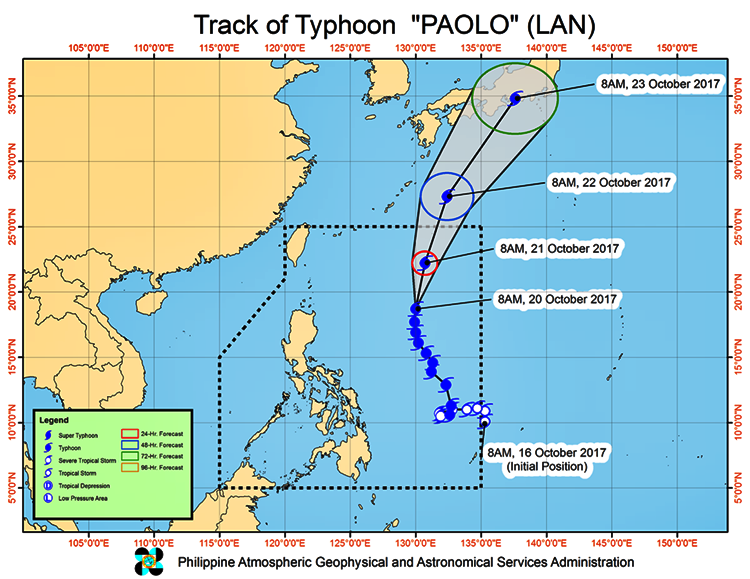
Bagyong Paolo which has an international name, Lan, has “slightly changed its course”.
It is now moving in the north northeast direction.
This was according to the bulletin of the state weather bureau Philippine Atmospheric, Geophysical and Astronomical Services Administration (PAGASA) issued at 11:00 AM, 20 October 2017.
Moderate to heavy rain is the estimated rainfall amount within the 1350 km diameter of the Typhoon.
The typhoon is accordingly to make its way out of the country or the Philippine Area of Responsibility (PAR) by Sunday morning (22 October).
At 10:00 AM today, the location or the eye of the typhoon, based on all available data, was located at 860 km East of Basco, Batanes (19.0 °N, 130.0 °E).
Its maximum sustained winds of 130 kph near the center and gustiness of up to 160 kph.
It is forecasted to move North Northeast at 16 kph.
Forecast Positions:
24 Hour(Tomorrow morning): 930 km East Northeast of Basco, Batanes(22.2°N, 130.7°E)
48 Hour(Sunday morning):1,310 km Northeast of Basco, Batanes (OUTSIDE PAR)(27.3°N, 132.4°E)
72 Hour(Monday morning): 2,215 km Northeast of Basco, Batanes (OUTSIDE PAR)(34.8°N, 137.6°E)
As of press time, there was no tropical cyclone warning signal that has been raised.
NOTE: “The public and the disaster risk reduction and management council concerned are advised to take appropriate actions and watch for the next update to be incorporated in the 4 PM Public Weather Forecast and in the next Severe Weather Bulletin to be issued at 11 PM today.”
Meanwhile, as of 10:00 AM today, the Low-Pressure Area (LPA), based upon the report, was at 105 km South of San Jose, Occidental Mindoro (11.5°N, 120.9°E).
This is based on all available data.
Moreover, the report wrote, “this weather system, along with the outer rainbands of “PAOLO” and the southwesterly windflow enhanced by this Typhoon will bring scattered to widespread rains and thunderstorms over Visayas and the regions of MIMAROPA and Bicol.”
The residents of the said area are highly advised and alerted against possible flashfloods and landslides because of moderate to occasionally heavy rains.
Travelling at sea is still risky over the following areas: seaboard of Northern Luzon, the eastern seaboard of Central and Southern Luzon, the seaboard of Palawan, the western and eastern seaboards of the Visayas and the western, northern and eastern seaboards of Mindanao.
What can you say about this?
Read also the previous article: Marian Rivera Clarifies “Snubbing Issue” With Cristine Reyes