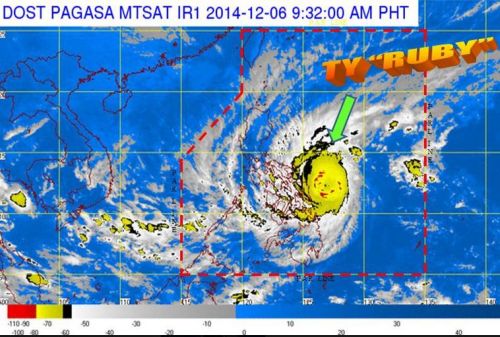
The Philippine Atmospheric, Geophysical and Astronomical Services Administration (PAGASA) announced the public storm warning signal into No. 3 over three Samar provinces, as Bagyong Ruby (Hagupit) moves closer to landfall in the country. As of 4:00 AM today, Bagyong Ruby has maintained its strength, packing maximum sustained winds of 195 kph with gusts of 230 kph and was spotted at 240 km East Northeast of Borongan, Eastern Samar.
See Also: Bagyong Ruby December 6, 2014 Hourly Update
The weather disturbance has slowed down with its movement, now moving west at 10 kilometers per hour, down from the 13 kph movement on Friday afternoon. PAGASA expects that Bagyong Ruby will make a landfall on Saturday evening or Sunday morning over the Eastern Samar-Northern Samar area.
According to PAGASA weather forecaster Fernando Cada, the weather agency are expecting Bagyong Ruby to weaken as it nears landfall. PAGASA already raised the public storm warning signals in a total of 37 areas across the country which will be affected by typhoon Ruby.
Here’s the Public Storm Warning Signals:
Signal No. 3 (winds of 105-185 kph in at least 18 hours)
Eastern Samar
Northern Samar
Samar
Signal No. 2 (winds of 61-100 kph expected in at least 24 hrs)
Luzon
Catanduanes
Albay
Sorsogon
Masbate, including Ticao Island
Visayas
Biliran
Leyte
Southern Leyte
Northern Cebu including Cebu City
Bantayan Island
Camotes Island
Mindanao
Dinagat Province
Signal No. 1 (winds of 30-60 kph expected in at least 36 hours)
Luzon
Camarines Norte
Camarines Sur
Burias Island
Romblon
Southern Quezon
Marinduque
Visayas
Capiz
Iloilo
Antique
Aklan
Negros Oriental
Negros Occidental
Rest of Cebu
Bohol
Mindanao
Surigao del Sur
Surigao del Norte including Siargao Island
Agusan del Norte
Agusan del Sur
Camiguin

