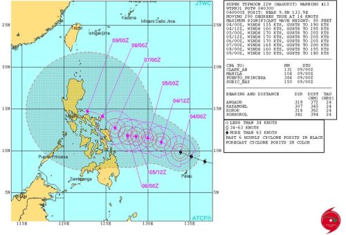
International weather agency, the Hawaii-based Joint Typhoon Warning Center (JTWC) of the United States (US) Navy has categorized tropical cyclone (Bagyong Ruby) into a super typhoon. The term “super typhoon” is utilized by the JTWC for typhoons that reach maximum sustained winds of at least 130 knots or 240 kph. This is equivalent to Category 4 or 5 hurricane in the Atlantic basin or Category 5 in Australian basin.
According to JTWC’s update issued at 5:00 AM Thursday (Manila time), Hagupit was maintaining a “west-northwestward trajectory under the steering influence of the subtropical ridge.”
The JTWC clarified further that the super typhoon Hagupit (Bagyong Ruby) forecasts to pack as much as 296 kph (160 knots) winds by December 7, Sunday, at around 2:00 PM when its nearer the Philippines.
Contrary to Japanese Meteorological Agency’s forecast that Hagupit will head towards Central Visayas, the JTWC noted that the super typhoon Hagupit is seen heading slightly north and towards Luzon, avoiding the Yoland-hit region of Visayas.
Meanwhile, the Philippine weather bureau, PAGASA, said that the tropical cyclone Hagupit, which was locally named “Ruby” was packing maximum sustained winds of 175 kph near the center and gusts of up to 210 kph.
PAGASA said Hagupit was spotted 942 kms east northeast of Hinatuan, Surigao del Sur as of 4 a.m. It said Hagupit slowed down, moving west northwest at 25 kph.

