The Marikina River is under the second alarm.
MARIKINA RIVER – It has breached the second alarm level at 16.4 meters on Monday afternoon, July 21, which signals pre-emptive evacuation.
On Monday afternoon, July 21, the Sto. Niño Water Level Gauging Station recorded the second alarm level of the Marikina River. This occurred as the Severe Tropical Storm Crising (international name Wipha) and the enhanced southwest monsoon continue to lash Metro Manila.
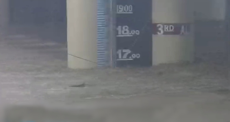
According to the Marikina City Public Information Office, the water reached 16.40 meters as of 4:40 PM. This prompted the authorities to advise residents in low-lying areas and those living near the river to evacuate to designated barangay evacuation centers.
Under Marikina’s flood warning system, the first alarm is at 15 meters, the second alarm is at 16 meters, and the third alarm is at 18 meters, which will require forced evacuation in high-risk communities.
Meanwhile, a red alert was also declared in Pasig City on Monday as the Wawa Dam overflowed, triggered by heavy southwest monsoon rains, as per Mayor Vico Sotto. Wawa Dam’s critical level is set at 135 meters above sea level, and the Marikina River will inevitably swell once Wawa Dam overflows.
The Marikina River is the largest tributary of the Pasig River before it flows to Manila Bay. This is why if the Wawa Dam overflows, the city would be affected.
Montalban Municipality Mayor Ronnie Evangelista said in a video that if the situation doesn’t improve, they will enforce a forced evacuation for residents who are living in dangerous areas.
In the latest from DOST-PAGASA, the elevation of Wawa Dam is above overflow level as of 5 PM.
While the country is still experiencing the lash of the southwest monsoon, a low-pressure area (LPA) was spotted east of southeastern Luzon, and another LPA was spotted east of Calayan, Cagayan.
What can you say about this? Let us know in the comments!