PAGASA Releases Latest Weather Update for Wednesday (September 8)
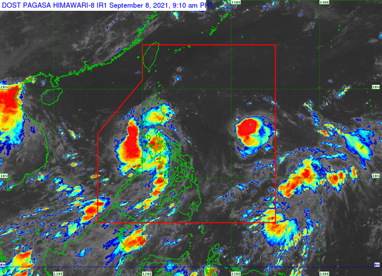
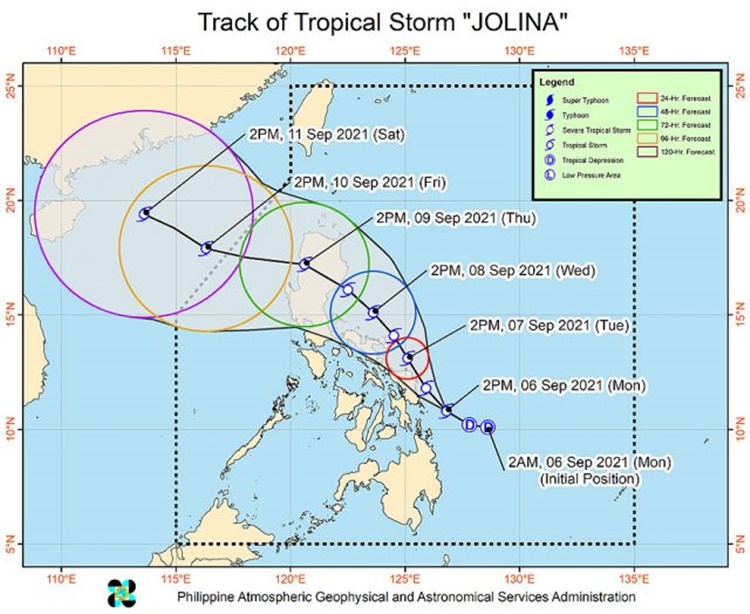
The state weather bureau PAGASA has placed 15 areas under signal no. 2 due to the effects of Severe Tropical Storm Jolina while Typhoon Kiko intensifies.
On Wednesday (September 8, 2021), the Philippine Atmospheric, Geophysical and Astronomical Services Administration released the latest weather update in the country. Severe Tropical Storm Jolina and Typhoon Kiko would affect the country’s weather condition.
Jolina has been last spotted over the coastal waters of Boac, Marinduque. It has maximum sustained winds of 100 kilometer per hour, gustiness of up to 150 kph, and central pressure of 996 hPa.

The Severe Tropical Storm Jolina would bring stormy weather condition with possible flash floods or landslides during moderate to heavy rains over Metro Manila, CALABARZON, Romblon, Marinduque, and Mindoro provinces.
Rainy weather condition with gusty winds are expected over Central Luzon, La Union, Pangasinan, and Camarines provinces. Light damage are expected in vegetations and some structures due to moderate to strong winds.
The weather disturbance would also bring cloudy weather condition with scattered rainshowers and thunderstorms over rest of Luzon, Western Visayas, Zamboanga Peninsula, Basilan, Sulu, and Tawi-Tawi.

Here is the list of areas under Tropical Wind Cyclone Signal (TCWS) No. 2:
- Northern portion of Romblon
- Marinduque
- Northern and central portions of Oriental Mindoro
- Northern and central portions of Occidental Mindoro
- Central and southern portions of Quezon Batangas
- Batangas
- Cavite
- Laguna
- Rizal
- Metro Manila
- Southern portion of Bulacan
- Pampanga
- Bataan
- Zambales
- Tarlac
Here are the areas under TCWS No. 1:
Luzon
- La Union
- Southern portion of Benguet
- Southern portion of Nueva Vizcaya
- Southern portion of Aurora
- Pangasinan
- Nueva Ecija
- Rest of Bulacan
- Rest of Quezon including Polillo Islands
- Camarines Norte
- Western portion of Camarines Sur
- Western portion of Albay (Libon, Oas, City of Ligao, Pio Duran, Polangui)
- Northwestern portion of Masbate (Aroroy) including Burias Island
- Rest of Romblon the rest of Oriental Mindoro
- Rest of Occidental Mindoro
Visayas
- Northwestern portion of Antique
- Northern portion of Aklan
Meanwhile, Typhoon Kiko intensifies as it is last located at 1,175 kilometers east of Central Luzon. Kiko has maximum sustained winds of 150 kilometers per hour and gustiness of up to 185 kph.

The weather agency warned the public that sea venture remains risky due to rough sea conditions.
What can you say about the latest weather update? Just feel free to leave your comments and reactions to this article.
Thank you for visiting Philippine Trending News (Philnews.ph). You may also follow us on the following social media platforms; Facebook, Twitter, and YouTube.
Read Also: PAGASA: Typhoon Jolina Whips Samar, 4 Areas Placed Under Signal No. 3
