PAGASA Releases Latest Weather Update for Wednesday (March 31)
The state weather bureau PAGASA reported that a low-pressure area entered the country and would bring rains over Visayas and Mindanao.
On Wednesday (March 31, 2021), the Philippine Atmospheric, Geophysical and Astronomical Services Administration released the latest weather updates in the country. A low-pressure area would affect the country’s weather condition.
The low-pressure area has been last spotted 180 kilometers southwest of General Santos City. The weather disturbance is expected to bring rain showers over some parts of Visayas and Mindanao.
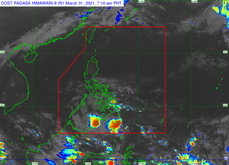
The LPA would bring cloudy weather condition with scattered rainshowers and thunderstorms over Mindanao, Eastern Visayas, Central Visayas, and Negros Occidental.
The easterlies would bring partly cloudy to cloudy condition with isolated rainshowers or thunderstorms over the provinces of Batanes, Cagayan, Isabela, Quirino, Nueva Vizcaya, Aurora, Apayao, Kalinga, Mountain Province, Ifugao, Abra, Benguet, Ilocos Norte, Ilocos Sur, La Union and Pangasinan.
The localized thunderstorms are also expected to bring the same weather condition over the rest of Visayas, Occidental Mindoro, and Palawan including Kalayaan Group of Islands, according to the weather bureau. The LPA has a slim chance of developing into a storm.
The weather agency also warned the public to take precautionary measures for possible flash floods or landslides during heavy rains.
Meanwhile, the coastal water conditions over Northern Samar, entire Visayas, Occidental Mindoro, and Palawan including Kalayaan Islands would be slight to moderate.
What can you say about the recent weather update? Just feel free to leave your comments and reactions to this article.
Read Also: PAGASA: LPA to Bring Rains in Mindanao, Warm Weather Expected Nationwide