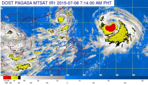
The country’s weather bureau, the Philippine Atmospheric, Geophysical and Astronomical Services Administration confirmed on Tuesday night that the latest weather disturbance, Bagyong Falcon entered the Philippine Area of Responsibility at around 9:30 PM on Tuesday night. According to PAGASA’s latest update, Bagyong Falcon was spotted at 1,250 km East of Calayan, Cagayan at around 10:00 today, July 8, 2015.
Bagyong Falcon is packed maximum sustained winds of 130 kph near the center and gustiness of up to 160 kph. The Tropical Storm, Bagyong Falcon is forecast to move West Northwest at 20 kph.
Although Bagyong Falcon will not directly hit the country, PAGASA warned that the weather disturbance could enhance the southwest monsoon (habagat) and will bring heavy rains and possible flooding.
Here’s the Forecasts of PAGASA on Bagyong Falcon’s Location:
24 hour (Tomorrow morning):
810 km East Northeast of Itbayat, Batanes
48 hour (Thursday morning):
Outside the Philippine Area of Responsibility (PAR) or at 585 km North Northeast of Itbayat, Batanes
72 hour (Friday morning):
740 km North Northwest of Itbayat, Batanes (Outside PAR)


