
PAGASA Releases Latest Weather Update for Saturday (July 11, 2026)
PAGASA LATEST UPDATE – The state weather bureau reported that Typhoon Inday is set to leave the Philippine Area of Responsibility today.
On Saturday (July 11, 2026), the Philippine Atmospheric, Geophysical and Astronomical Services Administration released the latest weather update in the country. Typhoon Inday will continue to affect the country’s weather condition.
Inday was last spotted 500 kilometers northeast of Itbayat, Batanes with maximum sustained winds of 140 kilometers per hour and gustiness of up to 170 kph. It is moving 20kph at a northwestward direction.

The typhoon will bring heavy rainfall over Zambales, Bataan, Occidental Mindoro, and Antique.
Moderate rainfall is expected over La Union, Pangasinan, Benguet, Tarlac, Pampanga, Bulacan, Metro Manila, Rizal, Cavite, Laguna, Batangas, Oriental Mindoro, Romblon, Palawan, Aklan, Capiz, Iloilo, Guimaras, Negros Occidental, and Negros Oriental.
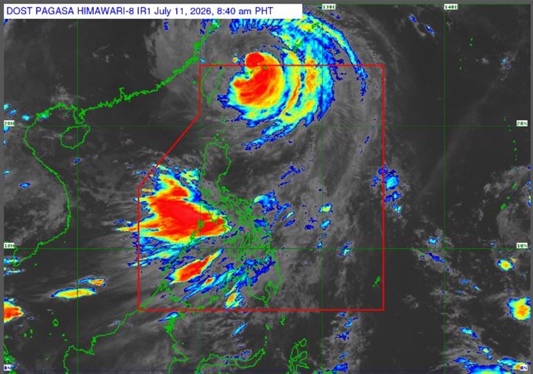
However, TCWS No. 1 is still up in three areaS:
- The rest of Batanes
- Babuyan Islands
- The northern portion of mainland Cagayan
Typhoon Inday is expected to make a landfall or pass over close to Sakishima Islands in southern Japan before exiting the Philippine Area of Responsibility.
“Inday is forecast to remain as a typhoon within the next 12 hours before weakening into a severe tropical storm after moving further inland over mainland China,” PAGASA said.
The weather system is also enhancing the Southwest Monsoon, which will bring strong to gale-force gusts over most parts of the country.
The weather agency advised the fisherfolks to take precautionary measures as sea travel remains risky. A gale warning is still up over the northern and eastern seaboards of Northern Luzon.
This is a developing report, just visit this website regularly or refresh the page for further updates.
READ ALSO: PAGASA: Typhoon Inday Weakens, Signal No. 2 Up in 3 Areas