Here’s an update about Mirasol PH, a tropical depression.
MIRASOL PH – The Philippine Atmospheric, Geophysical and Astronomical Services Administration (PAGASA) released the latest update.
In the latest weather bulletin from the Philippine Atmospheric, Geophysical and Astronomical Services Administration (PAGASA), Mirasol PH has become a tropical depression.
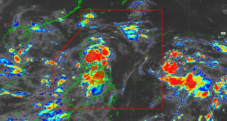
Based on the update, it is about to make landfall over the northern portion of Aurora. Its center was located over the coastal waters of Casiguran, Aurora, at 1 AM. It has maximum sustained winds of 55 km/h near the center, gustiness of up to 75 km/h, and a central pressure of 1006 hPa, and moves westward at 15 km/h.
Signal No. 1 in these areas:
- Luzon
- Batanes, Cagayan including Babuyan Islands, Isabela, Quirino, the northern and eastern portions of Nueva Vizcaya (Diadi, Quezon, Kasibu, Dupax del Norte, Bambang, Ambaguio, Bayombong, Solano, Villaverde, Bagabag, Alfonso Castañeda, Dupax del Sur), the northern and central portions of Aurora (Dilasag, Casiguran, Dinalungan, Dipaculao, Baler, Maria Aurora, San Luis), Apayao, Abra, Kalinga, Mountain Province, Ifugao, Ilocos Norte, the northern portion of Ilocos Sur (Sinait, Cabugao, San Juan, Magsingal, Santo Domingo, Bantay, San Vicente, San Ildefonso, Santa Catalina, City of Vigan, Caoayan, Santa), Polillo Islands, and the northern portion of Camarines Norte (Capalonga, Jose Panganiban, Paracale, Vinzons)
According to the forecast, Mirasol will move north northwestward while slightly decelerating, approaching the Isabela-Aurora area. However, if MIRASOL shifts more toward a north-northwest or northward track, it is likely to avoid landfall and instead pass over the coastal waters of Northern and Central Luzon. It will cross Northern Luzon and re-emerge over the Luzon Strait by this evening, then move generally northwestward until it exits the Philippine Area of Responsibility between tomorrow afternoon and evening.
In another outlook, it will maintain its strength or will slightly weaken as it crosses the Northern Luzon landmass. Once it passes through the Luzon Strait, it may intensify and reach tropical storm category by tomorrow morning. Intensification to severe tropical storm is not ruled out.
Meanwhile, the Southwest Monsoon will bring strong to gale-force gusts in the following areas:
- Today, at the southern portion of Quezon, the rest of Camarines Norte that is not under Wind Signal, Marinduque, Romblon, the southern portion of Mindoro provinces, and Panay Island.
- Tomorrow, on September 18, in Panay Island, Palawan, Mindoro Provinces, Marinduque, Romblon, the southern portion of Quezon, Camarines Norte, Isabela, Cagayan, including Babuyan Islands, Batanes, Ilocos Norte, Ilocos Sur, La Union, and Pangasinan.
- On Friday, September 19, at Ilocos Norte, Ilocos Sur, La Union, Pangasinan, Zambales, and Bataan
What can you say about this? Let us know in the comments!