PAGASA Says LPA to Affect PH Weather Condition
PAGASA LATEST UPDATE – The state weather bureau reported that a low-pressure area will bring rains over parts of the country.
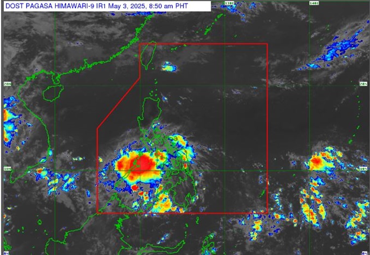
On Saturday (May 3, 2025), the Philippine Atmospheric, Geophysical and Astronomical Services Administration released the latest weather update in the country. A low-pressure area will affect the country’s weather conditions.
PAGASA specialist Obet Badrina reported that a low-pressure area off the coast of northeastern Mindanao will bring cloudy skies with scattered rains and thunderstorms over Visayas, Mindanao, Bicol Region, MIMAROPA, Quezon, and Batangas.
“For now, based on the latest data collected, the low-pressure area we’re monitoring still has a low chance of becoming a typhoon,” Badrina said.
The LPA was last spotted 135 kilometers east of Surigao City, Surigao del Norte.
“It may move toward the Visayas, approach the area of Palawan, and go through to the area of the West Philippine Sea,” he added.
The low-pressure area has a high chance of rain in the Bicol and Mimaropa regions as well as the provinces of Batangas and Quezon.
“A big part of Palawan, especially the southern part of Palawan, will experience rain today and in the coming days due to the approaching low-pressure area,” he explained.
The easterlies will bring partly cloudy to cloudy skies with isolated rain showers or thunderstorms over Metro Manila and the rest of Luzon.
Warm weather with isolated rain showers or thunderstorms is expected over the rest of Luzon.
The weather agency has advised the residents in the affected areas to take precautionary measures for possible flash floods or landslides due to moderate to at times heavy rains.
Meanwhile, the coastal water conditions across the country will be slight to moderate, according to PAGASA. No gale warning was raised over any of the country’s seaboard.
RELATED ARTICLE: PAGASA Releases Latest Weather Update for Friday (May 2, 2025)