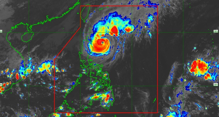
PAGASA released a Typhoon Marce Update and here are some details.
TYPHOON MARCE UPDATE – These areas are under Signal No. 1, 2, and 3, and here’s the latest forecast about the typhoon.
Marce PH intensified and Typhoon Signal No. 3 has been in effect for Sta. Ana, Cagayan. In an update, the same area remains under Signal No. 3, and according to the Philippine Atmospheric, Geophysical, and Astronomical Services Administration (PAGASA), the typhoon became “almost stationary over the waters east of Northern Cagayan”.

At 4 PM, it was spotted 295 km East of Aparri, Cagayan with maximum sustained winds of 150 km/h near the center and gustiness of up to 185 km/h.
Based on the update, Tropical Cyclone Wind Signals were in effect in various areas of the country.
Signal No. 1 (Minimal to minor threat to life and property)
Luzon
- The rest of Ilocos Sur, La Union, the northwestern portion of Pangasinan (Bani, Bolinao, Anda, City of Alaminos, Agno, Sual), the rest of Abra, the rest of Kalinga, Mountain Province, Ifugao, Benguet, the rest of Isabela, Quirino, Nueva Vizcaya, and the northern portion of Aurora (Dilasag, Casiguran, Dinalungan, Dipaculao, Maria Aurora, Baler)
Signal No. 2 (Minor to moderate threat to life and property)
Luzon
- Batanes, the rest of Cagayan including the Babuyan Islands, the northern portion of Isabela (Maconacon, San Pablo, Santa Maria, Divilacan), Apayao, the northern portion of Kalinga (Rizal, Pinukpuk, Balbalan), the northern portion of Abra (Langiden, Bangued, Danglas, Tayum, La Paz, Dolores, Lagayan, San Juan, Lagangilang, Tineg, Lacub, Licuan-Baay, Malibcong), Ilocos Norte, and the northern portion of Ilocos Sur (Sinait, Cabugao, San Juan, Magsingal, Santo Domingo, Bantay, San Ildefonso, San Vicente, Santa Catalina)
Signal No. 3 (Moderate to significant threat to life and property)
Luzon
- The northeastern portion of mainland Cagayan (Santa Ana, Gonzaga)
According to the forecast, Marce is moving slowly to the west-northwestward direction before it will gradually accelerate to the west on November 7 until November 9 over the Babuyan Channel and the northern portion of the West Philippine Sea.
It will make landfall and traverse the Babuyan Islands and the northern portions of mainland Cagayan, Ilocos Norte, and Apayao on the afternoon of November 7 to the early morning of November 8. It is expected to remain in the typhoon category throughout its passage in the country.
What can you say about this? Let us know in the comments!
