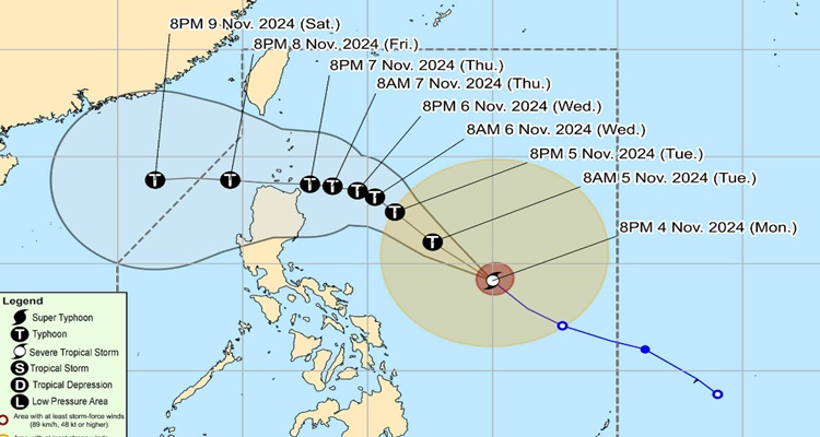
Here’s a Bagyong Marce Update, now a severe tropical storm.
BAGYONG MARCE UPDATE – PAGASA released an update about Marce which has now developed into a severe tropical storm.
A few hours ago, Marce was seen gaining its strength off Bicol and was forecasted to intensify rapidly. Based on a previous update about Marce PH from the Philippine Atmospheric, Geophysical, and Astronomical Services Administration (PAGASA), it has further intensified over the Philippine Sea east of Bicol Region on Monday afternoon.

It is expected to reach the typhoon category by Tuesday evening, November 5, or early Wednesday morning, November 6.
In the 11 PM bulletin from PAGASA, Marce has developed into a severe tropical storm and “undergoes rapid intensification. At 4 PM, the center was 715 km East of Daet, Camarines Norte.
Based on recent data, it now has maximum sustained winds of 100 km/h near the center and gustiness of up to 125 km/h. It is moving northwestward at 35 km/h.
Tropica Cyclone Wind Signal is now in effect and Signal No. 1 was raised in:
- Luzon
- Batanes, the northern and eastern portions of Cagayan (Camalaniugan, Lal-Lo, Pamplona, Gonzaga, Santa Teresita, Baggao, Buguey, Santa Ana, Claveria, Gattaran, Peñablanca, Lasam, Aparri, Ballesteros, Abulug, Allacapan, Sanchez-Mira, Santa Praxedes, Alcala, Amulung, Iguig) including Babuyan Islands, the eastern portion of Isabela (Maconacon, San Pablo, Divilacan, Palanan, Dinapigue), the northern portion of Apayao (Santa Marcela, Luna, Calanasan, Flora, Pudtol), and the northern portion of Ilocos Norte (Pagudpud, Dumalneg, Adams, Bangui, Burgos, Pasuquin, Vintar)
The highest Wind Signal possible during the occurrence would be Signal No. 4.
Generally, the severe tropical storm will be moving west-northwestward until November 5 and the bureau warns that rapid intensification is likely. It can possibly intensify into a typhoon by Tuesday evening or early Wednesday.
What can you say about this? Let us know in the comments!
