PAGASA Announces Typhoon Mangkhut Enters PAR, Expected To Bring Rains Stronger Than Ondoy
PAGASA announced that Typhoon Mangkhut has already entered the Philippine Area of Responsibility (PAR) and expected to bring rains stronger than Ondoy.
On Wednesday afternoon (September 12, 2018), the Philippine Atmospheric, Geophysical and Astronomical Services Administration (PAGASA) announced that Typhoon Mangkhut has entered the country’s vicinity.
Mangkhut is was named “Ompong” packing maximum sustained winds of 205 kilometers per hour (kph) and gustiness of up 255 kph moving 20 kph at a west direction.
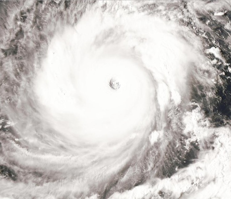
Ompong was last spotted Northeast of Guiuan, Eastern Samar and may traverse the Cagayan-Batanes around Saturday (September 15, 2018).
However, Tropical Cyclone Warning Signal #1 might be raised over Eastern Luzon tonight or tomorrow morning (September 13).
PAGASA revealed that the rains brought by Ompong could stronger than the rain of Ondoy last 2009.


“Kamukha din noong panahon ni Ondoy, habagat din ‘yun. So kung may habagat din siya plus ‘yung ulan mismo ay nanggagaling sa bagyo so puwede siyang (tubig) tumaas. Puwedeng abutin si Ondoy, puwedeng lagpasan ang Ondoy dahil meron itong sinasabi natin na habagat,” PAGASA administrator Dr. Vincent Malano said.
Here are the forecast positions of the typhoon:
- Thursday morning (September 13, 2018) – 805 km East of Virac, Catanduanes
- Friday morning (September 14, 2018) – 605 km East of Baler, Aurora
- Saturday morning (September 15, 2018) – Vicinity of Aparri, Cagayan
- Sunday morning (September 16, 2018) – 590 km West of extreme Northern Luzon (Outside PAR)
- Monday morning (September 17, 2018) – 1,125 km West of extreme Northern Luzon(Outside PAR)

What can you say about this? Just feel free to leave your comments and reactions to this article.
READ ALSO: Mangkhut’s Space Photo Approaching the Philippines