The Philippine Atmospheric, Geophysical and Astronomical Services Administration (PAGASA) announced on Wednesday, September 13, 2017, that Tropical Storm Maring has slightly intensified and is now approaching the western boundary of the Philippine Area of Responsibility (PAR).
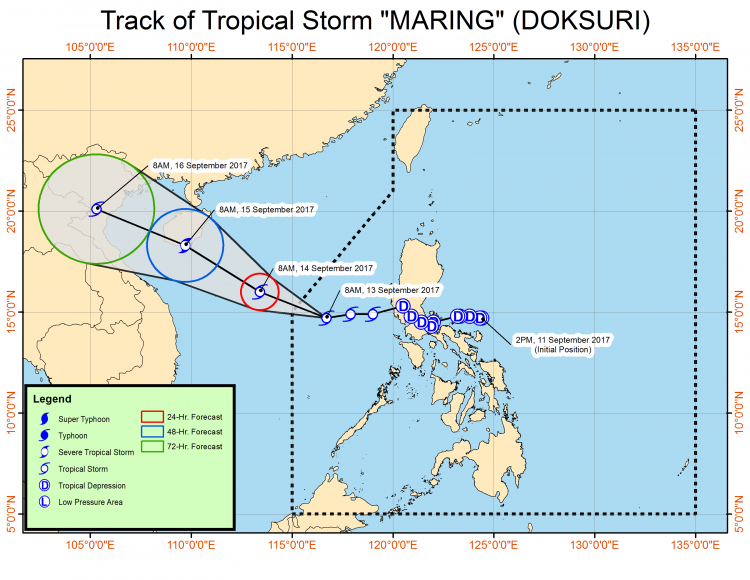
Based on the advisory issued by the state weather bureau, Maring was spotted at 370 km West of Iba, Zambales (14.8 °N, 116.6 °E).
Tropical Storm Maring has maximum sustained winds of 85 kph and gustiness of up to 105 kph.
Maring is forecast to move West Northwest at 18 kph.
According to PAGASA, the estimated rainfall amount of Tropical Storm Maring is moderate to heavy within the 350 km diameter.
Here’s the forecast position of Tropical Storm Maring in the following days:
- 24 Hour(Tomorrow morning): 565 km North of Pagasa Island, Palawan (OUTSIDE PAR)(16.0°N, 113.4°E)
- 48 Hour(Friday morning):945 km North Northwest of Pagasa Island, Palawan (OUTSIDE PAR)(18.3°N, 109.7°E)
- 72 Hour(Saturday morning): 1,385 km Northwest of Pagasa Island, Palawan (OUTSIDE PAR)(20.1°N, 105.3°E)
Tropical Storm “Maring” is expected to exit PAR this late afternoon or evening.
There’s no Tropical Cyclone Warning Signal (TCWS) issued by the Bureau but it reminded the public especially the fishermen and travelers that sea travel remains risky over the western seaboards of Central and Southern Luzon.
Note: Please refresh the post for updates.