Based on the latest from PAGASA, Typhoon Uwan intensified, and the TCWS currently in effect.
Typhoon Uwan threatens Luzon, and according to the latest from PAGASA, these are the areas currently under Signal No.
The Philippine Atmospheric, Geophysical, and Astronomical Services Administration (PAGASA) just released a new bulletin about Uwan PH, with the international name Fung-Wong. This potentially strong typhoon that will likely reach the super typhoon category is threatening Luzon.
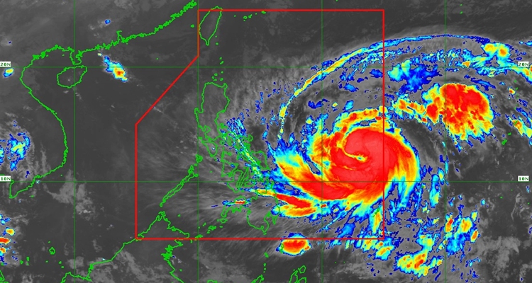
Based on the early update from PAGASA, Uwan is moving west northwestward at 25 km/h over the sea east of Eastern Visayas. At 4 AM, its center was at 985 km East of Eastern Visayas and had maximum sustained winds of 130 km/h near the center, gustiness of up to 160 km/h, and a central pressure of 965 hPa.
TROPICAL CYCLONE WIND SIGNALS (TCWS) IN EFFECT
Signal No. 1
- Luzon
- Cagayan including Babuyan Islands, Isabela, Quirino, Nueva Vizcaya, Apayao, Abra, Kalinga, Mountain Province, Ifugao, Benguet, Ilocos Norte, Ilocos Sur, La Union, Pangasinan, Aurora, Nueva Ecija, Bulacan, Tarlac, Pampanga, Zambales, Bataan, Metro Manila, Cavite, Laguna, Batangas, Rizal, Quezon including Polillo Islands, Camarines Norte, Camarines Sur, Albay, Sorsogon, Masbate including Ticao Island and Burias Islands, Marinduque, Romblon, Oriental Mindoro, Occidental Mindoro including Lubang Islands, and Calamian Islands
- Visayas
- The rest of Northern Samar, the rest of Samar, the rest of Eastern Samar, Biliran, Leyte, Southern Leyte, the northeastern portion of Bohol (Getafe, Talibon, Buenavista, Trinidad, San Miguel, Ubay, Alicia, Mabini, Bien Unido, Pres. Carlos P. Garcia), the northern and central portions of Cebu (Medellin, Daanbantayan, City of Bogo, Tabogon, San Remigio, Tabuelan, Borbon, Sogod, Tuburan, Catmon, Carmen, Danao City, Compostela, Liloan, Consolacion, Lapu-Lapu City, Mandaue City, Cordova, Asturias, Cebu City, Balamban, City of Talisay, Toledo City, Minglanilla) including Bantayan and Camotes Islands, the northern portion of Negros Occidental (City of Escalante, Toboso, Sagay City, Cadiz City, Calatrava, Manapla, City of Victorias, Enrique B. Magalona, Silay City, City of Talisay, San Carlos City, Salvador Benedicto, Murcia, Bacolod City), the northern and central portions of Iloilo (Carles, Estancia, Balasan, San Dionisio, Concepcion, Batad, Sara, Ajuy, Barotac Viejo, San Rafael, Lemery, Lambunao, Calinog, Bingawan, City of Passi, San Enrique, Anilao, Banate, Dingle, Dueñas, Janiuay, Badiangan, Mina, Pototan, Barotac Nuevo, Dumangas), Capiz, Aklan and the northern and central portions of Antique (Pandan, Libertad, Sebaste, Culasi, Valderrama, Tibiao, Barbaza, Laua-An, Bugasong) including Caluya Islands
- Mindanao
- Dinagat Islands and Surigao del Norte
Signal No. 2
- Luzon
- Catanduanes
- Visayas
- The eastern and central portions of Northern Samar (Lope de Vega, Palapag, Las Navas, Mapanas, Laoang, Catubig, Mondragon, Lapinig, Pambujan, Catarman, San Roque, Silvino Lobos, Gamay), the northeastern portion of Samar (Matuguinao, San Jose de Buan), and the northern portion of Eastern Samar (Maslog, San Policarpo, Dolores, Jipapad, Oras, Arteche)
The highest Wind Signal that will likely be hoisted throughout its passage is Wind Signal No. 5, as per PAGASA.
Based on PAGASA’s forecast, Uwan may make landfall over the southern portion of Isabela or the northern portion of Aurora tomorrow (November 9) in the late evening or Monday early morning.
It will rapidly intensify until it reaches the super typhoon category tonight or tomorrow morning. The terrain, based on the track, will weaken it, but is expected to remain in the typhoon category throughout its passage.
What can you say about this? Let us know in the comments!