Here’s an update about Dante PH and Habagat from PAGASA.
DANTE PH – In the 11 PM update from PAGASA, here are the forecasts about the tropical depression and the southwest monsoon.
Based on the update from the Philippine Atmospheric, Geophysical, and Astronomical Services Administration (PAGASA), Dante, one of the two low pressure areas (LPAs) being observed inside the Philippine Area of Responsibility, slightly intensified as it moves northwestward over the Philippine Sea at 25 km/h.
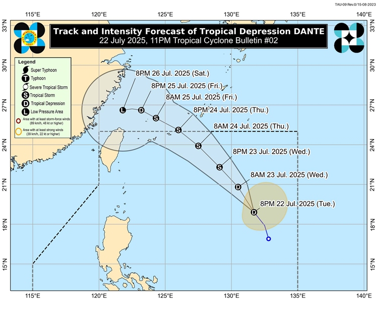
As of 10 PM, its center was at 1,055 km East of Extreme Northern Luzon (19.0°N, 131.5°E). In terms of intensity, it has maximum sustained winds of 55 km/h near the center, gustiness of up to 70 km/h, and a central pressure of 998 hPa.
There are currently no tropical cyclone wind signals being observed as of this posting.
Apart from Dante, another LPA is also being observed inside the PAR, identified as “LPA 7h,” which has a medium potential of being developed into a tropical depression in the next 24 hours.
There is also another LPA spotted outside the PAR identified as “LPA 07i.” This also has a medium chance of turning into a tropical depression within the next 24 hours.
About the Southwest Monsoon or Habagat
For several days now, several parts of the country have been drenched and submerged because of the heavy and continuous rains. In the latest based on post from PAGASA, the downpour would continue until tomorrow evening, July 23.
Here’s the heavy rainfall outlook:
Tonight to Tomorrow evening (July 23)
- (>200 mm):
- Zambales, Bataan, Metro Manila, Cavite, and Occidental Mindoro
- (100-200 mm):
- Pangasinan, Benguet, Tarlac, Pampanga, Bulacan, Batangas, Laguna, and Rizal
- (50-100 mm):
- Ilocos Norte, Ilocos Sur, La Union, Abra, Nueva Vizcaya, Ifugao, Nueva Ecija, Quezon, Oriental Mindoro, Palawan, Marinduque, Romblon, Masbate, Sorsogon, Albay, Camarines Sur, Catanduanes, Antique, and Iloilo
Tomorrow evening to Thursday evening (July 24)
- (>200 mm):
- Pangasinan, Zambales, and Bataan
- (100-200 mm):
- La Union, Benguet, Pampanga, Bulacan, Metro Manila, Cavite, Batangas, Laguna, Rizal, and Occidental Mindoro
- (50-100 mm):
- Ilocos Norte, Ilocos Sur, Abra, Ifugao, Mountain Province, Nueva Vizcaya, Tarlac, Nueva Ecija, Quezon, Oriental Mindoro, Palawan, Marinduque, Romblon, and Antique
Thursday evening to Friday evening (July 25)
- (100-200 mm):
- La Union, Pangasinan, Zambales, and Bataan
- (50-100 mm):
- Ilocos Norte, Ilocos Sur, Apayao, Abra,Benguet, Tarlac, Pampanga, Bulacan, Metro Manila, Cavite, Batangas, Rizal, Laguna, Occidental Mindoro, Palawan, and Antique
What can you say about this? Let us know in the comments!