In an update, Tropical Storm Crising maintains strength and is now over the coastal waters of Calayan, Cagayan.
TROPICAL STORM CRISING – The Philippine Atmospheric, Geophysical, and Astronomical Services Administration (PAGASA) released an update.
Tropical Storm Crising (Wipha) has maintained its strength. According to the Philippine Atmospheric, Geophysical, and Astronomical Services Administration (PAGASA), its center was spotted over the coastal waters of Calayan, Cagayan (19.4°N, 121.6°E).
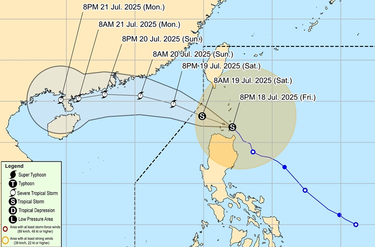
It moves northwestward at 15 km/h, and Signal numbers 1 and 2 are still up in several areas.
Signal No. 2
- Batanes, Cagayan including Babuyan Islands, Isabela, Apayao, Kalinga, the northern and central portions of Abra (Manabo, Pidigan, San Juan, Tayum, Langiden, Boliney, Sallapadan, Bucloc, Lagangilang, Danglas, La Paz, Licuan-Baay, Tineg, Malibcong, Peñarrubia, San Isidro, Daguioman, San Quintin, Dolores, Lagayan, Bangued, Bucay, Lacub), the eastern portion of Mountain Province (Natonin, Paracelis), the eastern portion of Ifugao (Aguinaldo, Alfonso Lista), Ilocos Norte, and the northern portion of Ilocos Sur (Cabugao, Sinait, Magsingal, San Juan, San Ildefonso, Santo Domingo, Bantay, San Vicente, Santa Catalina, Caoayan, City of Vigan, Santa)
Signal No. 1
- Quirino, Nueva Vizcaya, the rest of Mountain Province, the rest of Ifugao, the rest of Abra, Benguet, the rest of Ilocos Sur, La Union, the northern portion of Pangasinan (San Nicolas, Natividad, San Quintin, San Manuel, Tayug, Sison, San Fabian, Pozorrubio, Laoac, Binalonan, San Jacinto, Manaoag, Mangaldan, Dagupan City, Binmaley, Lingayen, Labrador, Sual, City of Alaminos, Bolinao, Anda, Bani, Agno, Burgos, Mabini, Dasol, Calasiao, Santa Barbara, Mapandan, Bugallon), the northern portion of Aurora (Dilasag, Casiguran, Dinalungan, Dipaculao, Baler, Maria Aurora), and the northeastern portion of Nueva Ecija (Carranglan, Pantabangan)
In the next 24 hours, it will move west-northwestward and will intensify until it becomes a Severe Tropical Storm tomorrow evening or Sunday morning (20 July). However, it will be less likely to make landfall in the Babuyan Islands. It will continue to move west-northwestward until it exits the Philippine Area of Responsibility by tomorrow morning, July 19.
Meanwhile, on July 18, classes were also suspended in different parts of the country due to the tropical cyclone. The decision was made to ensure the safety of students and school personnel.
What can you say about this? Let us know in the comments!