PAGASA Releases Latest Weather Update for Thursday (July 17, 2025)
PAGASA LATEST UPDATE – The state weather bureau reported that signal no. 1 was raised in 26 areas due to Tropical Depression Crising.
On Thursday (July 17, 2025), the Philippine Atmospheric, Geophysical, and Astronomical Services Administration released the latest weather update in the country. Tropical Depression Crising will affect the country’s weather conditions.
PAGASA Weather Specialist Chenel Dominguez reported that Tropical Depression Crising was spotted 535 kilometers east of Juban, Sorsogon, with maximum sustained winds of 55 kilometers per hour and gustiness of up to 70 kph.

Crising was moving 15 kph in a west-northwest direction. The tropical depression will affect most parts of the country, while the southwest monsoon will affect Mindanao.
Tropical Cyclone Wind Signal (TCWS) No. 1 was raised in the following areas:
The tropical depression will bring cloudy skies with scattered rains and thunderstorms over the Bicol Region, Eastern Visayas, Isabela, Aurora, Quezon, Dinagat Islands, and Surigao del Norte.

Southeastern portion of Cagayan:
- Gattaran
- Baggao
- Peñablanca
Eastern portion of Isabela
- Maconacon
- Divilacan
- Palanan
- Dinapigue
- San Pablo
- Tumauini
- Ilagan City
- San Mariano
- San Guillermo
- Benito Soliven
- Echague
- Jones
- San Agustin
- Naguillian
- Cauayan City
- Angadanan
- Gamu
- Cabagan
- Reina Mercedes
Northeastern portion of Aurora
- Dilasag
- Casiguran
- Dinalungan
Northeastern portion of Quirino
- Maddela
“We expect that as Tropical Depression Crising approaches the landmass, the possibility of having tropical cyclone wind signals will also increase,” Dominguez said.
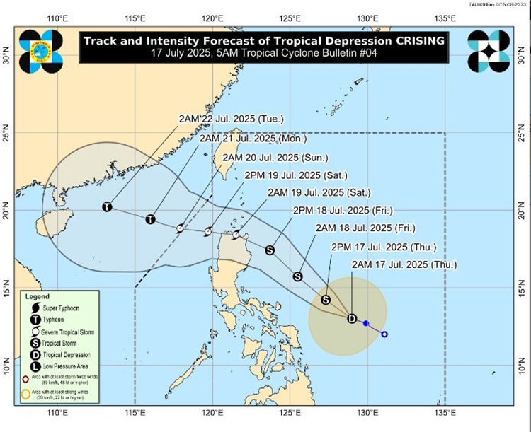
TD Crising is expected to leave the Philippine Area of Responsibility by Saturday evening (July 19) or Sunday morning (July 20).
Meanwhile, the southwest monsoon will bring cloudy skies with scattered rains and thunderstorms over Metro Manila, rest of Central Luzon, rest of CALABARZON, rest of MIMAROPA, Central Visayas, Zamboanga Peninsula, Northern Mindanao, rest of Caraga, La Union, and Pangasinan.
Habagat will bring occasional rains over Western Visayas, Negros Island Region, Palawan, and Occidental Mindoro.
Similar weather conditions are expected in the remaining parts of the country.
The weather agency has advised the residents in the affected areas to take precautionary measures for possible flash floods or landslides due to moderate to at times heavy rains and severe thunderstorms.
Motorbancas and similarly sized vessels are advised to take precautionary measures while venturing out to sea., according to PAGASA.