PAGASA Releases Latest Weather Update for Saturday (November 9, 2024)
PAGASA LATEST UPDATE – The state weather bureau reported that another low-pressure area has entered PAR and is expected to turn into a tropical cyclone.
On Saturday (November 9, 2024), the Philippine Atmospheric, Geophysical, and Astronomical Services Administration released the latest weather update in the country. A low-pressure area inside PAR will affect the country’s weather conditions.
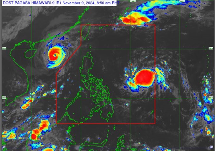
PAGASA weather specialist Daniel James Villamil reported that a low-pressure area east of the country is expected to turn into a tropical cyclone. The LPA entered the Philippine Area of Responsibility at 2 a.m. today.

The weather disturbance was last spotted 1,170 kilometers east of Southeastern Luzon. The LPA will be given the domestic name Nika once it becomes a tropical cyclone.
”This weather disturbance has a high chance of developing into a tropical cyclone within the next 12 hours,’‘ Villamil said.
Another LPA was located 2,870 km east of northeastern Mindanao. It has a slim chance of developing into a tropical cyclone.

“It has little chance of turning into a tropical cyclone in the next 24 hours, but it will gradually strengthen over the next few days,” Villamil said.
The easterlies and localized thunderstorms will bring partly cloudy to cloudy skies with isolated rain showers or thunderstorms over most parts of the country.
The weather agency has advised the residents in the affected areas to take precautionary measures for possible flash floods and landslides due to moderate to at times heavy rains and severe thunderstorms.
Typhoon Yinxing, formerly Marce was spotted 500 km west of Laoag City with maximum sustained winds of 155 kilometers per hour and gustiness of up to 190 kph. It was moving west-northwestward at 20 kph.
Meanwhile, the coastal water condition throughout the country will be slight to moderate, according to PAGASA.
RELATED ARTICLE: PAGASA: Typhoon Marce Weakens, to Exit PAR on Friday Afternoon (November 8, 2024)
