PAGASA Releases Latest Weather Update for Friday (November 8, 2024)
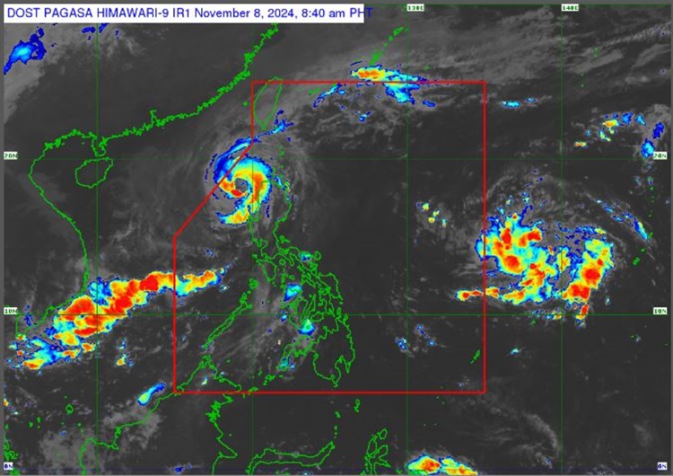
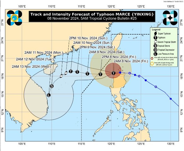
PAGASA LATEST UPDATE – The state weather bureau reported that Typhoon Marce has weakened as it is expected to leave PAR today.
On Friday (November 8, 2024), the Philippine Atmospheric, Geophysical, and Astronomical Services Administration released the latest weather update in the country. Typhoon Marce will affect the country’s weather conditions.
PAGASA reported that Typhoon Marce is now over the sea west of Ilocos Norte. Signal No. 4 was still up in five areas as it is expected to exit the Philippine Area of Responsibility this afternoon.

Marce has maximum sustained winds of 155 kph and gustiness of up to 215 kph. It is moving West Northwestward at the speed of 10 kph.
The typhoon will bring stormy weather over Ilocos Norte and Ilocos Sur. It will also bring rains with gusty winds over the Cordillera Administrative Region, the rest of the Ilocos Region, Batanes, and Cagayan.
Typhoon Marce’s trough will bring cloudy skies with scattered rains and thunderstorms over Central Luzon and the rest of Cagayan Valley.

The localized thunderstorms will bring partly cloudy to cloudy skies with isolated rain showers or thunderstorms over Metro Manila and the remaining parts of the country.
The weather agency has advised the residents in the affected areas to take precautionary measures for possible flash floods and landslides due to moderate to heavy rains and severe thunderstorms.
Another low-pressure area has formed in the east of the country. It has a slim chance of intensifying into a tropical depression in the next 24 hours but may enter PAR by Friday evening or Saturday morning (November 9).

Meanwhile, the coastal water condition over Northern Luzon and the western section of Central Luzon will be rough. Moderate to rough surrounding sea conditions are expected over the western section of Southern Luzon. Slight to moderate waters are expected over the rest of the country.
PAGASA also raised Tropical Cyclone Wind Signals in different areas of Luzon:
TCWS No. 4
- Ilocos Norte
- Northernmost portion of Ilocos Sur (Sinait, Cabugao)
- Northern portion of Abra (Danglas, Lagayan, Tineg)
- Northwestern portion of Apayao (Calanasan)
- Northwestern portion of mainland Cagayan (Sanchez-Mira, Claveria, Santa Praxedes)
TCWS No. 3
- Southern and western portion of Babuyan Islands (Fuga Is., Dalupiri Is., Calayan Is., Camiguin Is.)
- Northern and western portions of Cagayan (Piat, Santo Niño, Rizal, Aparri, Lasam, Camalaniugan, Buguey, Santa Teresita, Allacapan, Pamplona, Abulug, Ballesteros)
- Rest of Apayao
- Central portion of Abra (Lacub, San Juan, La Paz, Bangued, Langiden, San Quintin, Pidigan, Malibcong, Peñarrubia, Bucay, Licuan-Baay, Langailang, Dolores, Tayum, Sallapadan, San Isidro)
- Northern portion of Ilocos Sur (Santo Domingo, San Vicente, Santa Catalina, Bantay, San Ildefonso, City of Vigan, Caoayan, Santa, Narvacan, Nagbukel, Magsingal, San Juan)
TCWS No. 2
- Southern portion of Batanes (Mahatao, Uyugan, Basco, Ivana, Sabtang)
- Rest of Babuyan Islands
- Rest of mainland Cagayan
- Northern and western portions of Isabela (San Pablo, Santa Maria, Tumauini, Maconacon, Cabagan, Santo Tomas, Quezon, Mallig, Delfin Albano, Quirino, Gamu, Roxas, Burgos, Reina Mercedes, Luna, Aurora, San Manuel, San Mateo, Cabatuan)
- Rest of Abra
- Kalinga
- Mountain Province
- Northern portion of Ifugao (Alfonso, Lista, Aguinaldo, Mayoyao, Banaue, Hungduan)
- Northern portion of Benguet (Bakun, Mankayan)
- Rest of Ilocos Sur
- Northern portion of La Union (Sudipen, Bangar, Balaoan, Luna, Santol, Bacnotan)
TCWS No. 1
- Rest of Batanes
- Rest of La Union
- Pangasinan
- Rest of Ifugao
- Rest of Benguet
- Rest of Isabela
- Quirino
- Nueva Vizcaya
- Northern and central portions of Aurora (Dilasag, Casiguran, Dinalungan, Dipaculao)
- Northern portion of Nueva Ecija (Carranglan)
- Northern portion of Zambales (Santa Cruz, Candelaria)
RELATED ARTICLE: Typhoon Marce Update – Sanchez-Mira, Cagayan Faces Another Landfall
