PAGASA Says Severe Tropical Storm Kristine to Affect PH Weather Condition
PAGASA LATEST UPDATE – The state weather bureau reported that severe tropical storm Kristine gradually slowed down.
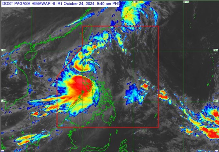
On Thursday (October 24, 2024), the Philippine Atmospheric, Geophysical and Astronomical Services Administration released the latest weather update in the country. Severe tropical storm Kristine will affect the country’s weather condition.
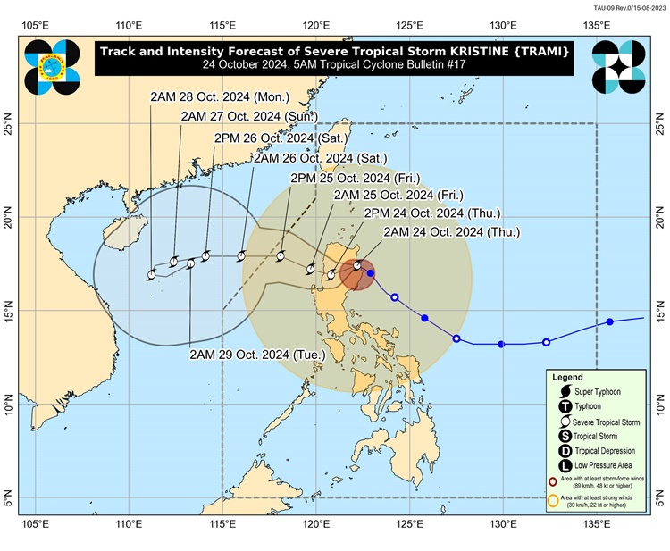
PAGASA reported that Kristine was estimated in the vicinity of Tumauini, Isabela. It has maximum sustained winds of 95 kilometers per hour and gustiness of up to 160 kph.
Kristine will bring story weather over Metro Manila, Ilocos Region, Cordillera Administrative Region, Cagayan Valley, Central Luzon, and CALABARZON.
The severe tropical storm will bring gusty winds and rains over Western Visayas, the rest of Luzon, Northern Samar, and Samar.
The trough of Severe Tropical Storm Kristine will bring cloudy skies with scattered rains and thunderstorms over Zamboanga Peninsula, Lanao del Norte, Lanao del Sur, Misamis Occidental, and the rest of Visayas.
It will also bring partly cloudy to cloudy skies with isolated rainshowers or thunderstorms over the rest of Mindanao.
In another post, Kristine Ph: old man dies after being trapped inside the house due to flood
PAGASA also raised Tropical Cyclone Wind Signals in the following areas:
TCWS No. 3
- the southern portion of Cagayan
- Isabela
- Quirino
- Nueva Vizcaya
- Kalinga
- Mountain Province
- Ifugao
- the southern portion of Abra
- Benguet
- the northern and central portions of Aurora
- the northern portion of Nueva Ecija
- the northern portion of Tarlac
- the northern portion of Zambales
- Pangasinan
- La Union
- the central and southern portions of Ilocos Sur
TCWS No. 2
- Ilocos Norte
- the rest of Ilocos Sur
- Apayao
- the rest of Abra
- the rest of Cagayan
- Babuyan Islands
- the rest of Aurora
- the rest of Nueva Ecija
- Bulacan
- the rest of Tarlac
- Pampanga
- the rest of Zambales
- Bataan
- Metro Manila
- Cavite
- Laguna
- Rizal
- Batangas
- the northern and central portions of Quezon
TCWS No. 1
- Luzon
- Batanes
- the rest of Quezon
- the rest of Occidental Mindoro
- Oriental Mindoro
- Marinduque
- Romblon
- the northern portion of mainland Palawan
- Camarines Norte
- Camarines Sur
- Catanduanes
- Albay
- Sorsogon
- Masbate including Ticao and Burias Islands
- Visayas
- Aklan
- Capiz
- Antique including Caluya Islands
- Iloilo
- Guimaras
- the northern portion of Negros Occidental
- the northern portion of Cebu including Bantayan Islands
- Northern Samar
- Samar
- Biliran
- the northern portion of Eastern Samar
- the northern portion of Leyte
The weather agency has advised the residents in the affected areas to take precautionary measures for possible flash floods or landslides due to moderate to at times heavy rains and severe thunderstorms.
Meanwhile, the coastal water conditions over Northern, Central Luzon, rest of Luzon, and Visayas will be rough. Mindanao will have moderate to rough coastal water conditions, according to PAGASA.
The weather disturbance is expected to cross Northern Luzon over the next 12 hours and will leave the Philippine Area of Responsibility (PAR) region on Friday afternoon.