PAGASA – Typhoon Ramon Slows Down, Approaches Babuyan Islands
PAGASA – Weather bureau PAGASA recently said that typhoon Ramon recently slowed down as it approadhes the Babuyan Group of Islands.
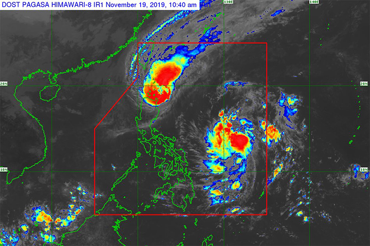
The bureau added that the weather disturbance was last spotted at about 120 kilometers east of the town of Calayan in Cagayan and is currently moving nearly stationary.
According to ABS-CBN, it is currently packed with about 120 kilometer per hour of maximum sustained winds and gusts of up to 165 kilometers per hour.
As mentioned before, Tropical Cyclone Wind Signal Number 3, where the bureau warned of facing wind speeds of about 121 to 170 kilometers per hour within 18 hours, is raised by the following areas:
- northern portion of Cagayan
- Santa Praxedes
- Claveria
- Sanchez Mira
- Pamplona
- Abulug
- Ballesteros
- Aparri
- Calayan
- Camalaniugan
- Buguey
- Santa Teresita
- Gonzaga
- Santa Ana
TCWS Number 2, where wind speeds of about 61 to 120 kilometers per hour will be faced within 24 hours, was raised over the following areas:
- Batanes
- Apayao
- Kalinga
- Abra
- Ilocos Norte
- Ilocos Sur
- the rest of Cagayan
TCWS No. 1 is raised over the following areas:
- North part of Isabela
- Sta. Maria
- San Pablo
- Maconacon
- Cabagan
- Sto. Tomas
- Quezon
- Delfin Albano
- Tumauini
- Divilacan
- Quirino
- Roxas
- Mallig
- San Manuell
- Burgos
- Gamu
- Ilagan City
- Mountain Province
- Benguet
- Ifugao
- La Union
- Pangasinan
Based on the report, Ramon was expected to weaken after its landfall on Tuesday afternoon or evening due to the landfall and amihan or the northeast monsoon.
However, Batanes, north Cagayan, Babuyan Islands, Apayao and the north part of Ilocos Norte will face moderate with frequent heavy rains from Ramon.
Meanwhile, the northern portion of Isabela, Kalinga, Abra, the rest of Cagayan, and Ilocos Sur, will face light to moderate with intermittent heavy rains.
The bureau warned fishermen of risky sea travel over the coasts of areas under TCWS, the seaboards of south Isabela, and the seaboards of Zambales and Bataan.
The typhoon is expected to leave the Philippine Area of Responsibility (PAR) on Thursday.
The low pressure area (LPA), that was observed by the bureau, on the other hand, is seen at about 720 kilometers east of the town of Guiuan, Eastern Samar. It is expected to enhance into a tropical depression within 24 hours.
What do you think? How will you react to this? Let us know more about it.
Check out our latest news at philnews.ph