Another Low-Pressure Area Enters PAR, PAGASA Said
The state weather bureau PAGASA announced that another low-pressure area has entered the Philippine Area of Responsibility (PAR).
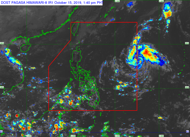
On Tuesday afternoon (October 15, 2019), the Philippine Atmospheric, Geophysical and Astronomical Services Administration released the latest weather updates in the country. PAGASA said that a low-pressure area entered the country’s vicinity.
PAGASA reported that the weather disturbance was last spotted at 970 kilometers east of Legazpi City in Albay. The low-pressure area has a low chance of developing into a tropical depression.
“Hindi naman natin ito nakikitang magiging isang ganap na bagyo subalit posibleng magdala pa rin ng mga pag-ulan sa mga susunod na araw sa silangang bahagi ng Kabisayaan at sa southern Luzon,” weather specialist Meno Mendoza said.
Northeasterly Surface Windflow is currently affecting the weather condition in Luzon. Gale warning has been also raised over Batanes, Babuyan Group of Islands, Ilocos Norte, and Cagayan.
The weather agency has also warned the fisherfolk and those with small seacraft that sea travel remains risky due to rough surrounding sea conditions. Meanwhile, the Intertropical Convergence Zone (ITCZ) would bring rains over parts of Mindanao.
What can you say about this? Just feel free to leave your comments and reactions to this article.