Tropical Storm Carina Increase Slightly off Ilocos Norte
Tropical Storm Carina Increase Slightly off Ilocos Norte. The storm signals were rise on some area of Northern and Central Luzon today (August, 1 2016).
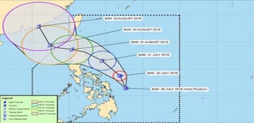
It was last seen 145 km northeast of Laoag City in Ilocos Norte and is forecast to move northwest at 20 kph (kilometer per hour) as PAGASA announced in weather bulletin his morning. It is estimated that Tuesday morning the storm is expected to leave the Philippine area of responsibility.
The storm Carina has a maximum wind of up to 105 kph near the center and gustily of up to 135 kph. In 500-km diameter it can bring heavy rains. In the seaboard in most of Luzon area PAGASA told that there will a very rough seas that the fishermen may experience due to the storm.
Signal No. 2 was raised on the following provinces.
- Ilocos Norte
- Apayao
- Abra
- Northern part of Cagayan, including Babuyan Group of Islands
See next page for continuation