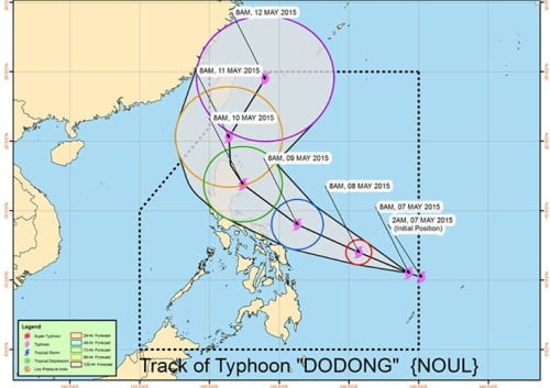
Bagyong Dodong (Tropical Cyclone Noul) enters the Philippine Area of Responsibility (PAR) before dawn on Thursday according to the latest weather bulletin released by the country’s weather bureau, PAGASA.
The Tropical Cyclone Noul (international name) was named as Bagyong Dodong as it entered the eastern portion of Mindanao on Thursday. At around 4:00 AM today, the tropical cyclone entered the Philippine Area of Responsibility.
Based upon PAGASA’s projection, Bagyong Dodong could get near Northern Luzon and affect the eastern section of Luzon, but the weather disturbance has a good chance of recurving and veering away. This means it could affect Bicol and Central Luzon and Northern Luzon.
PAGASA’s weather bulletin released at around 5:00 Am today, forecasts that Bagyond Dodong was estimated at 1,040 km east of Surigao City with maximum sustained winds of 130 kph near the center and gustiness of up to 160 kph. Bagyong Dodong is expected to move west-northwest at 150 kph.
The latest weather disturbance may affect the eastern section of Visayas within the next 24 hours. PAGASA noted that Bagyong Dodong is expected to be at 685 km east of Guiuan, Eastern Samar by Friday morning, and 450 km East of Catarman, Northern Samar on Saturday morning while on Sunday morning it is expected to be at 280 km southeast of Casiguran, Aurora.

