The country’s weather bureau PAGASA issued their sever weather bulletin #8 at around 11:00 AM today, April 4, 2015. According to PAGASA, Bagyong Chedeng has accelerated slightly as it continues to move closer to Isabela-Aurora area of Luzon island. The Storm Signals of Bagyong Chedeng and PAGASA’s Hourly Updates are available below.
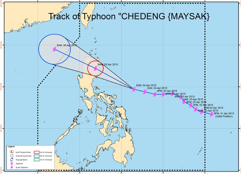
The weather disturbance is expected to make a landfall over the coast of Southern Isabela by Sunday morning (April 5, 2015) and will exit the Philippine landmass via Ilocos Sur by Sunday afternoon (April 5) and will exit the Philippine Area of Responsibility by Monday morning (April 6, 2015).
PAGASA noted that as of 10:00 AM today, Bagyong Chedeng was spotted based on all available data at 450 East Southeast of Casiguran, Aurora (14.7°N, 126.0°E). Bagyong Chedeng has a maximum sustained winds of 130 kph near the center and gustiness of up to 160 kph and forecast to move West Northwest at 22 kph.
The Local Government Units and PAGASA advised that residents in low lying and mountainous areas of the provinces with PSWS#2 and PSWS#1 are alerted against possible flashfloods and landslides. Storm Surges and sea surface waves could go up 2 meters over the eastern coast of Aurora, Quezon and Isabela.
Here’s the Public Storm Warning Signal No. 2: (Winds of 61-100 kph is expected it at least 24 hours)
1. Isabela
2. Southern Cagayan
3. Kalinga
4. Mt. Province
5. Ifugao
6. Benguet
7. Nueva Vizcaya
8. Quirino
9. Aurora
10 Catanduanes
Public Storm Warning Signal No. 1 (Winds of 30-60 kph is expected in at least 36 hrs)
1. Rest of Cagayan including Babuyan Island
2. Apayao
3. Ilocos Norte & Ilocos Sur
4. Abra
5. La Union
6. Pangasinan
7. Nueva Ecija
8. Tarlac
9. Pampanga
10. Bulacan
11. Rizal
12. Quezon
13. Camarines Norte & Camarines Sur
Here’s the Hourly Update of Bagyong Chedeng:
