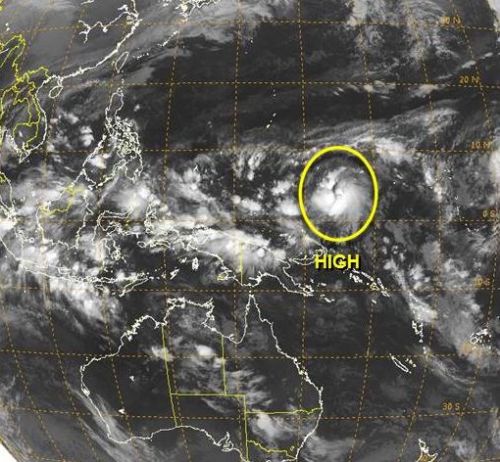
A possible super typhoon, which will be named as Bagyong Seniang will possibly hit the province of Cebu and the rest of the Visyas region this coming weekend as confirmed by PAGASA Visayas director Oscar Tablada in a report posted on Banat News of PhilStar Cebu.
Update: Bagyong Seniang Update December 28, 2014
Image Shown is Hagupit and NOT Seniang
PAGASA-Visayas clarified that a total of Low Pressure Area (LPA) are expected to enter the Philippine Area of Reaponsibility this weekend. The first LPA when formed will be named as Bagyong Ruby, while the second one will be called as Bagyong Seniang, which is forecasts to develop into a super typhoon.
Update: Bagyong Seniang Prediction by PAGASA Visayas Not a Forecast
According to Director Oscar Tablada, he fears that the path of Bagyong Seniang will follow the track of Bagyong Pablo, one of the strongest typhoon that hits Mindanao two years ago. Bagyong Pablo was packed with 280kph speed during its devastation in Mindanao last December 3, 2012.
The LPA which is forecasts to form into a super typhoon has some similaraties with Bagyong Pablo, the site of its origin was the same, formed near the center of the equator at the Pacific Ocean. The original forecast destination of Bagyong Pablo was the Province of Cebu and the entire Central Visayas but when it made a landfall it changed its course and devastates the provinces of Davao Oriental and Compostela Valley.
See Also: Bayong Ruby (Hagupit) Possible Scenarios as it Enters PAR
The government should prepare right now if ever these two weather disturbance will form into a typhoon, the earlier the preparation, the better. During the Bagyong Queenie that hits Bohol and Southern Cebu, the government immediately declared an early evacuation that saved the lives of some individuals affected by the typhoon.


According to the tropical cyclone points on this map it could hit higher and it looks like it is on a legapsi city / manila path rather than a visayas one. Could even potentially slam into Tacloban again which would be an absolute disaster a year on from yolanda. Looks like it will hit the philippines but too early to suggest just where. Another day or two should get a better idea.
http://www.ssd.noaa.gov/mtsat/twpac/loop-rb.html
we pray to the lord immediately hit super typhoon ruby and super typhoon seniang
Please PRAY always… GOD is good all the the time…
Ormoc City experiencing fine and sunny weather.