Sarangani Earthquake Magnitude 6.2 Rocks Davao del Sur

Earthquake

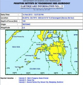
A magnitude 6.2 earthquakes strucked the vicinity of Sarangani Province in Davao del Sur at around 12:37 PM based upon the bulletin posted by the Philippine Institute of Volcanology and Seismology (PhiVolcs) on their official website. The United States Geological Survey have already confirmed the earthquake that struck the Philippines southern islands. As of this … Read more

Philippines 7.9 Magnitude Earthquake Evacuation and Damage Reports

Philippines 7.9 Earthquake Damages Reports and Evacuations

The USGS recorded 7.9 Magnitude earthquake caused the provinces of the two major islands in the Eastern Part of the Philippines to order an immediate evacuation. According to Samar Gov. Paul Daza that the evacuation is on going in the towns of Northern Samar particularly Lapinig, Gamay, Mapanas, Palapag, Lao-Ang, San Roque and Pambuan. A Congressman … Read more

Tsunami Warnings Issued After 7.9 Earthquake Hits the Philippine Coasts

7.9 Magnitude Earthquake

The USGS have confirmed the 7.9 Earthquake hits the Eastern coast of the Philippine island of Samar. The earthquake hits at around 12:47:34. The epicenter was located at 93 kms. East of Sulangan, Samar island in the Philippines with a depth of 34.9 kms. Here’s the estimated initial arrival of Tsunami in Different Parts of Asia: … Read more

7.9 Magnitude Earthquake Rocks Sulangan, Samar, Philippines

7.9 Earthquake in the Philippines

One of the strongest earthquake hits the Eastern part of the Philippines. It hits the South Pacific region of the Philippines. Here’s the complete details of the earthquake that hits the Philippines. It hits the Philippines at around 01:54:23 UTC+08:00 at epicenter. 236km (147mi) SE of Sarangani, Philippines 258km (160mi) NW of Tobelo, Indonesia 276km (171mi) SSE of Caburan, Philippines … Read more