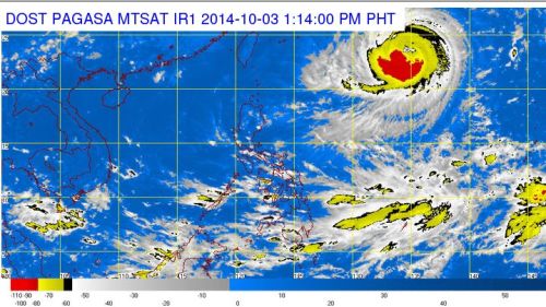
Bagyong Neneng whose international name is “Phanfone” already entered the Philippine Area of Responsibility (PAR) but there’s no direct impact in the country as confirmed by PAGASA on Friday, October 3, 2014. According to international weather bureau, Phanfone will affects the areas of neighboring Japan.
In an interview with DzMM, PAGASA forecaster Aldczar Aurelo noted that the Bagyong Neneng entered PAR at 11:00 AM on Friday, and was locally code-named “Neneng.” The weather disturbance, Bagyong Neneng was packing maximum sustained winds of 175 kilometers per hour (kph) near the center and gusts of up to 210 kph.
Based upon PAGASA’s forecast Bagyong Neneng was moving northwest at 20 kph., it will bring an estimated rainfall amount of 7.5 – 30 millimeters per hour (heavy-intense) in areas around the 700-km diameter of the typhoon Phanfone.
PAGASA also noted that Bagyong Neneng is expected to be at 1,180 kilometers northeast of Itbayat, Batanes or outside the Philippine Area of Responsibility (PAR) by Saturday morning.
The country’s weather bureau also stated that the typhoon is unlikely to enhance the southwest monsoon (habagat) because the Philippines is already experiencing a transition from southwest monsoon to northeast monsoon (amihan).

