Here’s an update about Uwan PH from PAGASA.
Uwan PH, with the international name Fung-Wong, is still outside PAR, and these areas in Luzon, Visayas, and Mindanao are now under Signal No. 1, according to PAGASA.
After Typhoon Tino battered most of the Visayas, and while the people are still reeling from the aftermath, another strong typhoon is set to pass the country with the international name Fung-Wong, domestically known as “Uwan.”
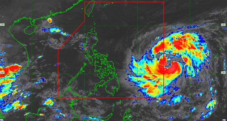
The Philippine Atmospheric, Geophysical, and Astronomical Services Administration (PAGASA) just released a new bulletin about Uwan PH. In the 5 PM update, several areas are already under Signal No. 1 despite the cyclone still outside the Philippine Area of Responsibility (PAR).
As of the weather bulletin, the center of the storm was last located at 4 PM at 1,175 km East of Eastern Visayas, moving westward at 25 km/h. It has maximum sustained winds of 110 km/h near the center, gustiness of up to 135 km/h, and a central pressure of 975 hPa.
TROPICAL CYCLONE WIND SIGNALS (TCWS) IN EFFECT
Signal No. 1
- Luzon
- The southeastern portion of Quezon (Tagkawayan, Guinayangan, Calauag, Lopez, Buenavista, Catanauan, Mulanay, San Narciso, San Andres, San Francisco), the eastern portion of Romblon (Cajidiocan, San Fernando, Magdiwang), Camarines Norte, Camarines Sur, Catanduanes, Albay, Sorsogon, and Masbate
- Visayas
- Northern Samar, Eastern Samar, Samar, Biliran, Leyte, Southern Leyte, the northern and central portions of Cebu (Medellin, Daanbantayan, City of Bogo, Tabogon, San Remigio, Tabuelan, Borbon, Sogod, Tuburan, Catmon, Carmen, Danao City, Compostela, Liloan, Consolacion, Lapu-Lapu City, Mandaue City, Cordova, Asturias, Cebu City, Balamban, City of Talisay, Toledo City, Minglanilla) including Bantayan and Camotes Islands, the northeastern portion of Bohol (Getafe, Talibon, Buenavista, Trinidad, San Miguel, Ubay, Alicia, Mabini, Bien Unido, Pres. Carlos P. Garcia), the northern portion of Negros Occidental (City of Escalante, Toboso, Sagay City, Cadiz City, Calatrava, Manapla), the northeastern portion of Capiz (President Roxas, Pilar, Panay, Pontevedra), and the northeastern portion of Iloilo (Carles, Estancia, Balasan, San Dionisio, Concepcion, Batad, Sara, Ajuy)
- Mindanao
- Dinagat Islands and Surigao del Norte
The highest Wind Signal that will likely be hoisted throughout its passage is Wind Signal No. 5, as per PAGASA.
According to the forecast, in the next 24 hours, Uwan will move generally westward, then turn west-northwestward, which will be its movement for most of the forecast period. Uwan will enter PAR tonight (November 7) or tomorrow (November 8) early morning.
It will rapidly intensify into a typhoon in the next 24 hours and a super typhoon by tomorrow evening or Sunday morning.
Uwan will likely make landfall over the southern portion of Isabela or the northern portion of Aurora on Sunday (November 9) late evening or on Monday (November 10) early morning.
What can you say about this? Let us know in the comments!