Here’s the update about Paolo PH and the tropical cyclone wind signals currently in effect.
PAOLO PH – PAGASA released an update about the tropical storm and the areas under tropical cyclone wind signal (TCWS).
Paolo has intensified into a tropical storm, according to the weather bureau, the Philippine Atmospheric, Geophysical, and Astronomical Services Administration (PAGASA). Based on the recent update, it is slightly intensifying, as it moves west-northwestward at 15 km/h over the Philippine Sea.
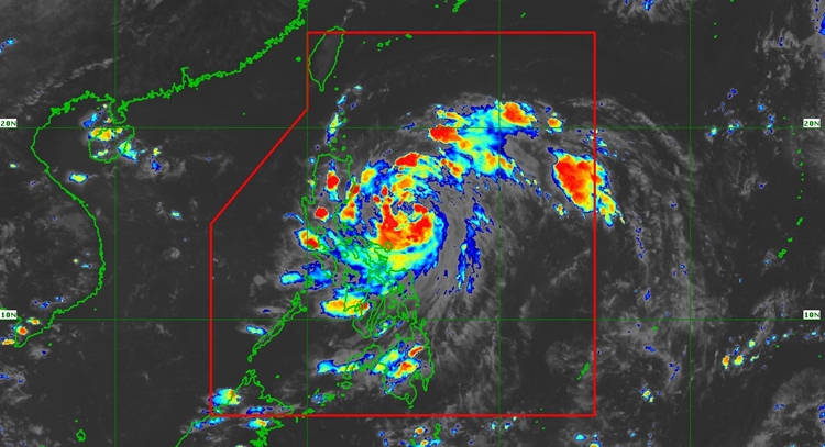
At 4 PM, the center was spotted at 480 km East of Infanta, Quezon, or 480 km East of Baler, Aurora (15.3°N, 126.1°E). Its intensity has maximum sustained winds of 85 km/h near the center, gustiness of up to 105 km/h, and a central pressure of 996 hPa.
TROPICAL CYCLONE WIND SIGNALS (TCWS) IN EFFECT
Signal No. 1
- Luzon
- Cagayan, the rest of Quirino, the rest of Nueva Vizcaya, Apayao, Abra, Benguet, Ilocos Norte, Ilocos Sur, La Union, Pangasinan, the northern portion of Zambales (Palauig, Masinloc, Candelaria, Santa Cruz), Tarlac, Nueva Ecija, the rest of Aurora, the northern portion of Bulacan (Doña Remedios Trinidad, San Miguel, San Ildefonso, Norzagaray, San Rafael), the northern portion of Pampanga (Magalang, Arayat, Candaba, Mabalacat City), the northern portion of Quezon (General Nakar, Infanta) including Polillo Islands, Camarines Norte, the northern portion of Camarines Sur (Siruma, Tinambac, Lagonoy, Garchitorena, Caramoan, Goa, San Jose, Presentacion), and Catanduanes
Signal No. 2
- Luzon
- Isabela, the northern portion of Quirino (Maddela, Aglipay, Cabarroguis, Saguday, Diffun), the northern portion of Nueva Vizcaya (Diadi, Bagabag, Quezon, Solano, Villaverde, Ambaguio, Bayombong, Kasibu), Kalinga, Mountain Province, Ifugao, and the northern portion of Aurora (Dilasag, Casiguran, Dinalungan)
Based on the forecast, Paolo may make landfall over southern Isabela or northern Aurora tomorrow morning, October 3.
After traversing Northern Luzon, it is expected to emerge over the West Philippine Sea by tomorrow afternoon and will continue moving west-northwest until it exits the Philippine Area of Responsibility on Saturday morning, October 4.
Intensification into a typhoon prior to landfall is possible.
What can you say about this? Let us know in the comments!