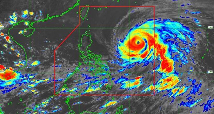
In the latest bulletin from PAGASA, Super typhoon Betty slightly weakens.
SUPER TYPHOON BETTY – State weather bureau PAGASA said that Super Typhoon Betty is now moving westward and these areas are in signal number 1.
Betty (international name: Mawar), is a super typhoon and is now moving westward at 25 kilometers per hour on Saturday afternoon. According to the latest bulletin from Philippine Atmospheric, Geophysical, and Astronomical Services Administration (PAGASA), it has slightly weakened as it moves towards the northern Philippines waters.
It has a maximum sustained winds of 185 kilometers per hour (kph) near the center which was previously at 195 kph based on the 11 a.m. bulletin. It gusts up to 230 kph which was previously 240 kph.
The center was last seen 1,035 km east of Central Luzon. In the latest bulletin, more areas are put under signal no. 1.

These areas are:
- Batanes
- Cagayan including Babuyan Islands
- Isabela
- Apayao
- Ilocos Norte
- the northern and central portions of Abra (Tineg, Lacub, Lagayan, San Juan, Lagangilang, Licuan-Baay, Malibcong, Danglas, La Paz, Dolores, Tayum, Bucay, Sallapadan, Daguioman, Bucloc, Boliney)
- Kalinga
- the eastern and central portions of Mountain Province (Sadanga, Barlig, Natonin, Paracelis, Bontoc)
- the eastern and central portions of Ifugao (Mayoyao, Aguinaldo, Alfonso Lista, Banaue, Hingyon, Lagawe, Lamut, Kiangan, Asipulo)
- the northern and central portions of Aurora (Dilasag, Casiguran, Dinalungan, Dipaculao)
- Quirino
- the northeastern portion of Nueva Vizcaya (Kasibu, Quezon, Solano, Bagabag, Diadi, Villaverde, Bayombong, Ambaguio)
The weather state bureau also warns these areas about strong winds. Monsoon rains will also be experienced in the western sections of MIMAROPA, Visayas, and Mindanao on Sunday.
“Betty is forecast to remain as a super typhoon over the weekend. Although it will likely maintain its strength for the next 36-48 hours, short-term intensification is not ruled out, especially in the next 12 to 24 hours,” PAGASA predicted.
PAGASA added that this may likely weaken on Monday or Tuesday as it “slowdown over the waters east of Batanes due to potentially unfavorable conditions.”
READ ALSO:
- Banks Rejecting National IDs Should Be Penalize – Gatchalian
- Oil Firms to Impose Gasoline Price Hike Next Week
What can you say about this? Let us know!
For more news and updates, follow us on Twitter: @philnews_ph Facebook: @PhilNews, and YouTube channel Philnews Ph.
