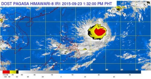
The country’s weather bureau, the Philippine Atmospheric Geophysical and Astronomical Services Administration (PAGASA) warned the Filipino public that Tropical Storm “Dujuan” is expected to enter the Philippine Area of Responsibility (PAR) on Wednesday night, September 23, 2015.
Tropical Storm “Dujuan” was last spotted at 1,745 kilometers east of Northern Luzon. Once the weather disturbance will enter the country it will be named as Bagyong Jenny.
The latest tropical storm that is expected to hit the country, Bagyong Jenny is expected to enter PAR by Wednesday evening or early Thursday morning.
Bagyong Jenny is packed a maximum sustained winds of 85 kilometers per hour near the center with gusts of 80 kph. It moved west northwest at 15 kph.
In an earlier reports by PAGASA forecaster, the storm is likely to directly affect the country and will recurve toward Japan. Aside from Bagyong Jenny, PAGASA also warned that the southwest monsoon (habagat) is currently affecting Visayas and Mindanao areas.

