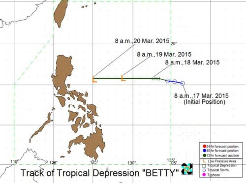
The newest weather disturbance to hit the Philippines, Bagyong Betty weakened further and is now considered as a “Tropical Depression” according to the latest update released by PAGASA on Wednesday, March 18, 2015. Based upon the 11:00 AM weather bulletin, Bagyong Betty was seen at 1,120 kilometers east of Casiguran, Aurora.
Bagyong Betty has maximum sustained winds of 45 kilometers per hour (kph) and is forecast to move west-northwest at 17 kph. In a recent interview with PAGASA weather forecaster Meno Mendoza, he said that “Betty” may further weaken and become a low pressure are in the next 24 hours.
PAGASA also forecasts that in the next 48 hours, the summer storm, Bagyong Betty may completely dissipate. The country’s weather bureau, PAGASA, expects that the weather disturbance will be at 705 km east of Casiguran, Aurora a a low pressure area on Thursday morning.
Aside from Bagyong Betty, PAGASA is not monitoring other incoming weather disturbances. The whole Philippines will experience cloudy to at times cloudy skies with isolated rainshowers or thunderstorms.
Moderate to strong winds blowing from the northeast to east will also prevail over the eastern section of Luzon.

