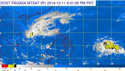
After Bagyong Ruby caused destruction in Eastern Visayas, Bicol Region, Southern Luzon and Mindoro, a new Low Pressure Area (LPA) currently spotted in the Pacific Ocean is threatening to develop into a typhoon and could strike the country this weekend. Right now, PAGASA, warned that the LPA could bring heavy rains in Cebu Province and the rest of the Visayas Region.
According to the latest weather bulletin of PAGASA issued at around 5:00 PM today, they noted that as of 4:00 PM, the LPA was estimated based on all available data at 1,390 km east of Mindanao. Northeast monsoon (amihan) will affect northern portion of Luzon island.
PAGASA stated although the LPA is still far from the country, the forecasters already saw cloud bands, wind surge could either prevent or encourage it from entering the country as a tropical depression.
Once the LPA will formed into a tropical depression as it enters the Philippine Area of Responsibility (PAR), it would be called “Bagyong Seniang.” The LPA, when develop into a typhoon will be the 19th tropical depression to enter the Philippines this year.
During the year 2013, the Philippines was visited with a total of 23 tropical depressions, including the most destructive super typhoon in the country’s history, the super typhoon Yoland which caused billions of damages to lives, infrastructures and properties.
PAGASA also warned that there is a possibility that the LPA will intensify into a tropical depression at the West Philippine Sea.

