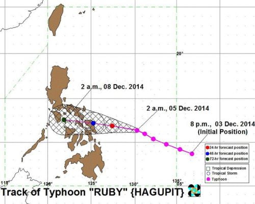
The Philippine Atmospheric, Geophysical and Astronomical Services Administration (PAGASA) released the latest update of Bagyong Ruby including its Public Storm Warning Signals and forecasts of the typhoon’s track as of Friday, December 5, 2014.
See Also: Bagyong Ruby December 6, 2014 (Saturday) Storm Signals
Based upon PAGASA’s weather bulletin issued today, Bagyong Ruby (Hagupit) has gained strength as it continues to move towards Eastern Visayas, but slightly slowed down at 13 kph and moving west northwest towards Eastern Visayas.
PAGASA forecasts that Bagyong Ruby is expected to make a landfall in the vicinity of Eastern Samar on Saturday night, December 6, 2014 or Sunday morning instead of Saturday afternoon, depending upon the movement of the typhoon at the Pacific Ocean.
As of 7:00 AM today, Bagyong Ruby was located at 455km East of Borongan, Eastern Samar, packing maximum sustained winds of 215 kph near the center and gusts of up to 250 kph. It is forecasts to be at 230 km East of Borongan, Eastern Samar tomorrow morning; 85 kms southeast of Catarman, Northern Samar on Sunday morning and at the vicinity of Romblon on Monday morning.
The country’s weather bureau already raised Public Storm Warning Signals in Over 34 Areas in the Philippines. Listed below are the areas affected by Public Storm Warning Signals.
Signal No. 2 (winds of 61-100 kph expected in at least 24 hrs)
LUZON
Sorsogon
Ticao Island
Masbate
VISAYAS
Northern Samar
Eastern Samar
Samar
Biliran
Leyte
Southern Leyte
Northern Cebu
Cebu City
Bantayan Island
Camotes Island
MINDANAO
Surigao del Sur
Agusan del Norte
Surigao del Norte
Dinagat Island
Siargao Island
Signal No. 1 (winds of 30-60 kph expected in at least 36 hours)
LUZON
Catanduanes
Albay
Camarines Norte
Camarines Sur
Burias Island
Romblon
VISAYAS
Capiz
Iloilo
Negros Oriental
Negros Occidental
Rest of Cebu
Siquijor
Bohol
MINDANAO
Misamis Oriental
Agusan del Sur
Camiguin Island

