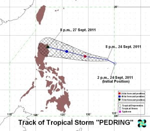
A stronger tropical storm is more likely to hit the northern part of Luzon as “Bagyong Pedring” slows down and gather more strength before it landed on the ground.
The Philippine Atmospheric Geophysical and Astronomical Services Administration have warned the residents in the area of Luzon to be more cautious and be ready for an expected heavy rain to pour down brought by tropical storm Pedring.
PAGASA is currently tracking the movement of the tropical storm and in the latest update it was spotted 260 kilometers of Virac, Catanduanes with a speed down to 17 kph from 28kph on Sunday.
Reports suggest that Tropical storm Pedring would likely hit the country Monday morning landing in most part of north Luzon while Metro Manila will also experience a rainy weather as Pedring continues to grow bigger as it p(–foul word(s) removed–) the Pacific Ocean.
Currently Tropical storm Pedring carries a wind with 110kph at the center with gustiness of 140 kph.
Storm Signals were already raised in some parts of the country including signal number 1 in places of Sorsogon, Quezon, Ifugao, provinces of Albay, Mt. province, Nueva Vizcaya, Cagayan and Calinga.
While Signal number 2 will be felt in Aurora, Polilio Island, Catanduanes, Isabela, Camarines Norte and Sur.
People living in the areas mentioned are advised to watch out in the possible landslide and flashflood and to take precautionary measure in case that the situation gets worst.
PAGASA have (–foul word(s) removed–)ured the public that time to time they will give an update on Tropical Storm Pedring for the citizens to be aware and be ready if anything happens.
