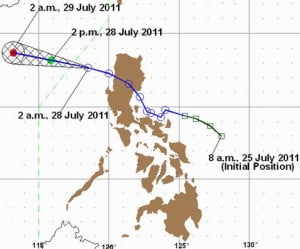
According to the latest updates from the Philippine Atmospheric Geophysical and Astronomical Services Administration, tropical storm Juaning will be out of the Philippine area of responsibility at around 8:00 to 10:00 AM, heading towards the West Philippine Sea. The weather bulletin have been issued by PAGASA at exactly 5:00 AM (PST) July 28, 2011.
PAG-ASA have posted on their official website the weather updates as of 5:00 AM (PST) “At 4:00 a.m. today, Tropical Storm “JUANING” was estimated based on radar, satellite and surface data at 240 km West Southwest of Laoag City (17.8°N 118.1°E) with maximum sustained winds of 95 kph near the center and gustiness of up to 120 kph. It is forecast to move West Northwest at 22 kph. ” stated by PAGASA on their website.
According to the latest updates from concerned government agencies Tropical Storm Juaning have left behind 37 total casualties and millions of damages to properties. Most fatalities came from the Bicol Region having registered a total of 9 from Albay, Camarines Norte 6, Catanduanes 4, Camarines Sur 2, and Quezon have 3 fatalities.
Cl(–foul word(s) removed–) that have been suspended earlier in Metro Manila will resumed today according to Department of Education and local government officials except for some places in Malabon area who were still suffering from flooding.
Storm Signal have been lifted in Metro Manila. Meanwhile Public storm signal was still effective in the areas of Ilocos Norte, Ilocos Sur, Abra, La Union, Pangasinan and Zambales. Other storm signals pertaining to tropical storm Juaning have already been lifted up. Storm signal number 1 have a strength of 45-60 kph winds.
The tropical storm Juaning with international code name: Nock-ten, a Laotian bird will be moving towards the West Philippine Sea and will be heading to China although weather analysts have stated that the track of the storm was unpredictable.
The next update from PAGASA will be released at around 11:00 AM (PST) July 28, 2011.
