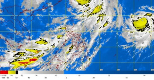
The country’s weather bureau, PAGASA warned the public that the strongest downpour in Luzon amid the intensified Habagat happened at around 2:00 AM and 8:00 AM on Friday morning. PAGASA noted that southwest was enhanced by Bagyong Falcon, affecting the entire western section of the Philippines.
Strong downpour affected the provinces of Zambales, Pangasinan, La Union and Baguio City while Metro Manila is expected to be affected by the heavy rains from early morning until early afternoon today.
PAGASA also warned about possible overflow of the La Mesa Dam and the Marikina River Basin. At around 4:30 AM, Friday, the water level at the dam is at 79.92 meters, which is near to its spilling level at 80.15 meters.
In the latest weather bulletin issued by PAGASA, Bagyong Falcon has gained strength as it exits the Philippine are of responsibility (PAR), on Friday morning. PAGASA’s 4:30 AM advisory stated that Bagyong Falcon has intensified further, packing maximum sustained winds of 160 kilometers per hour (kph) near the center and gustiness of up to 195 kph.
Bagyong Falcon was last spotted 890 kilometers north of Itbayat, Batanes. It continues to move northwest at 22 kph and was outside PAR Friday morning. PAGASA warned of heavy to intense rainfall within the 300-kilometer radius of the typhoon.
Falcon will also enhance the southwest monsoon and is expected to bring moderate to heavy rains over Luzon and Visayas but the weather bureau also noted that the weather will improve by Saturday.

