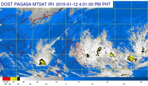
The country’s weather bureau, the Philippine Atmospheric, Geophysical and Astronomical Services Administration (PAGASA) forecasts that a potential cyclone will enter the Philippine Area of Responsibility on Thursday, January 15, 2015.
Once the Low Pressure Area (LPA) will develop into a tropical cyclone, PAGASA noted that it will be named as Amang, the first typhoon to enter the country this year. According to the latest weather bulletin of PAGASA released today, January 12, the LPA was spotted about 2,000 kilometers east of Visayas-Mindanao region.
PAGASA weather forecaster Buddy Javier said that the LPA could bring rains to parts of Visayas, including the province of Leyte which will be visited by Pope Francis this coming Saturday, January 17, 2015 as part of the Pope’s meeting with the victims of super typhoon Yolanda that hits last November 2013.
The forecasts LPA will have three possible scenarios according to PAGASA, first, the LPA could intensify and hit the Philippine landmass or re-curve north due to a high pressure area.
The last scenario is that, the LPA could dissipate before even making landfall due to the northeast monsoon that affecting the low pressure area as it nears the Philippines.
PAGASA forecasts today, that Eastern Visayas, CARAGA and Davao Region will experience cloudy skies with light to moderate rainshowers and thunderstorms. Cagayan Valley and Cordillera will have cloudy skies with light rains, Metro Manila and the rest of Luzon will be partly cloudy to at times cloudy with isolated light rains.
The rest of Visayas and Mindanao will experience partly cloudy to cloudy skies with isolated rainshowers or thunderstorms. Moderate to strong winds blowing from the northeast will prevail over the whole archipelago with moderate to rough seas.

