The Philippine Atmospheric, Geophysical and Astronomical Services Administration (PAGASA) released the latest weather update of Bagyong Mario as of Friday, September 19, 2014. According to PAGASA’s weather bulletin released at around 5:00 AM, Bagyong Mario has intensified and slowed down as it moves towards Northern portion of Luzon island.
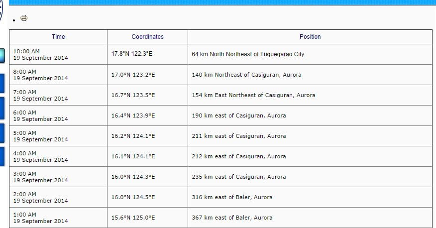
PAGASA noted that at around 4:00 AM today, Bagyong Mario was estimated based on all available datat at 212 km East of Casiguran, Aurora, it has a maximums sustained winds of 85 kph near the center and gustiness of up to 100 kph. The Tropical Storm Mario (Fung-wong) is forecast to move West Northwest at 22 kph.
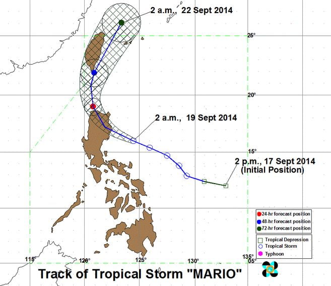
According the country’s weather bureau forecasts, Bagyong Mario is expected to be at 91 km North Northeast of Laoag City, Ilocos Norte by Saturday morning (September 20), and at 195 km Northeast of Basco, Batanes by Sunday morning (Sept. 21).
By Monday morning, September 21, 2014, Bagyong Mario is expected to be at 643 km North Northeast of Basco, Batanes or outside the Philippine Area of Responsibility (PAR).
Here’s the Latest Public Storm Warning Signals:
Signal No. 2 (winds of 61-100 kph): Cagayan, including Calayan and Babuyan Group of Islands, Isabela, Kalinga, Apayao, Mt. Province, Abra and Ilocos Norte.
Signal No. 1 (winds of 30-60 kph): Aurora, Quirino, Nueva Vizcaya, Quirino, Nueva Vizcaya, Ifugao, Benguet, Ilocos Sur, La Union and Batanes Grop of Islands.
Here’s the Hourly Updates of Bagyong Mario: